"Hard hitting and provocative as ever!"
--Linda Martin, BigfootSightings.org
"I keep dipping into your blog when I have a few minutes. Seems I have found my preferred source. I have to commend you on the intelligent, well-written, interesting, and informative posts you share. A refreshing and rare breath of fresh air on the topic of our favorite unknown..."
---Full Moon Magick Shoppe
"Very nice to meet you Steven, I am digging on your blog and your bookstore is now my favorite bookstore... EVER!"
--Bryan, Humboldt County, CA
I just thought I'd give you a quick call, and my congratulations on your excellent write-up in your blog. Well said, sir! Just stick to the facts, and never deviate from the facts, and you've got it right down the middle. Well done. Thank you.
---Thomas Steenburg, Bigfoot researcher, calling via phone, from British Columbia, Canada
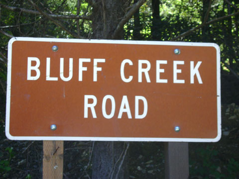
 MAY DAY 2010: SCOUTING OUT THE ROAD TO BLUFF CREEK.
No Bigfoot, No Access to PGF Site, but LOTS of Bears.
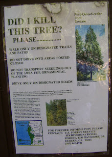
On the first of May, right after a week or so of unseasonable cold rain that included some higher elevation snow, the weather had suddenly begun to appear like Spring. Yours truly and Squatcher daughter, Denali, decided to go out on a Bigfooting scouting trip to the famous Bluff Creek area. At this time of year the roads into the real backcountry generally remain closed for the season, either because of snow and rock slides, or else in the case of the southern Fish Lake side of the Bluff Creek Road, due to the spreading and lingering threat of the Port Orford Cedar root rot fungal disease. Some of these roads to the famous Bigfoot sites will not open until sometime in June, maybe even later. Bigfooters get antsy to get back in there and do some Bigfooting, so we decided to check out the situation that lies in our own backyard.
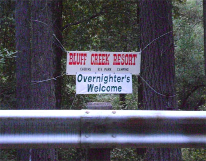
 First stop was the Bluff Creek Resort, formerly known as the Bluff Creek Company, where Patterson and Gimlin and so many other early Bigfooters bought provisions before making their way up the crazy, winding old Bluff Creek Road and into the still-wild backwoods mountains. This is where Roger Patterson filled up his tank with gas at the pumps right in front of this building.
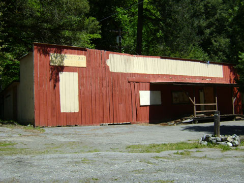
This used to be a bustling, thriving business back when there were still a lot of salmon in the Klamath River and adjoining creeks, and when Americans still seemed to appreciate the idea of leisure time spent out in the great outdoors. That has sadly declined over the years, and the old Bluff Creek Company Store building is, according to owner Phil Smith, Sr., scheduled for demolition.
Though he'd told us it would be a done deal and gone by last October, we were happy to find that the historical old building is still standing. However, it looks even worse for the wear of another winter, and the old remaining "Bluff Creek Comp..." signs on the front have been removed, and are stacked up like junk on the front porch. Mr. Smith remembers meeting Roger Patterson (but not Bob Gimlin) back in the sixties at the store, which his wife's family had owned over the years. He characterized Patterson as a sincere and determined man who really believed in the Bigfoot. From the stories of stinky, loud activity and footprint finds on the many-acre property around the resort, it's obvious that Mr. Smith believes in Bigfoot, too.
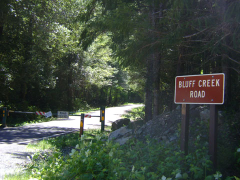
Right across the two-lane Highway 96 (Bigfoot Scenic Byway) is the newer entrance to Bluff Creek Road. The older starting area of the road, which Patterson and Gimlin and all the other Bigfooters and road contractors like Jerry Crew and Ray Wallace would have used, is a wild old series of switchbacks just up the road a touch from here, before one gets to Bluff Creek itself as it enters the Klamath River. The old switchbacks can still be made out on the mountainside above (sorry, we forgot to get a photo of this one).
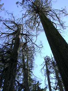
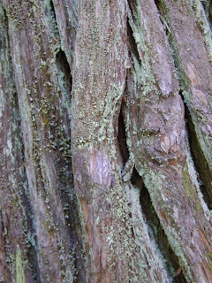
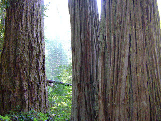
This road eventually leads up to Fish Lake and Blue Lake, areas with predominating, towering old growth Port Orford Cedars, heavy vacationing use in the summer, and actually loads of Bigfoot vocalization and wood knocking and other activity reports and sightings still coming in from there. Unfortunately, these lakes are also surrounded and infested by by the fungal disease (See our previous blog on that HERE). That means they are closed until the soil is basically dry, and not as likely to spread the spores on tires and boots.

We found, indeed, that the famous road that leads up to Onion Mountain and Blue Creek Mountain from the south-east was still closed. Anyone thinking of hopping the fence and hiking in should really consider that you may be helping to kill beautiful old growth trees, and that your vehicle will most likely be ticketed or towed if left along the highway pull-off. Plus, it is quite a nasty uphill haul of a hike. There are other ways in to the area that may give you access, including Cedar Camp Road, which appeared to have no barricade, but is probably mostly mud at places right about now. The G-O road is open, too, to the north, but hits snow at higher elevations (see below for that).
IMAGES: CLICK TO ENLARGE. The Port Orford sign will give you the lowdown on the situation. All photos save where noted or historical were taken by Steven Streufert, 2010. The first one below was shot by Denali Brown.
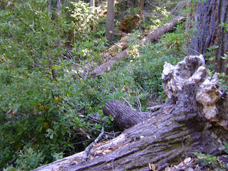
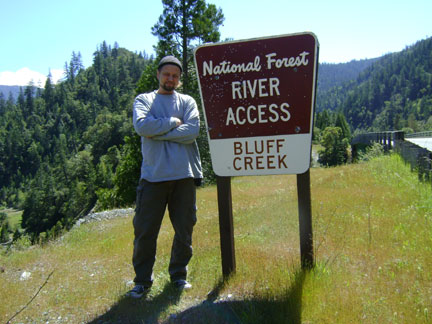 Soon after the road off to Fish Lake one comes to the small but dramatic canyon where Bluff Creek has eaten its way through the rock to get to the Klamath River.
 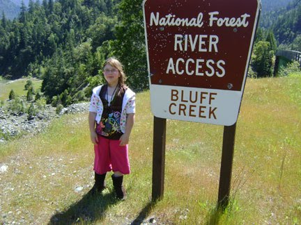 There the narrow Bluff Creek Bridge spans over its depths where one may view the raging snow melt pummeling the grey-blue serpentine rock and washing down whole downed trees in a wide "S" shaped curve. For a creek that is a trickling wade only a few inches deep upstream in summer, Bluff is impressive down here when there has been any significant level of recent rain.
 There is the Bluff Creek River Access trail here down to the river. It was an enjoyable short hike, but there certainly is no possibility of swimming this early in the year. You'd have to be crazy to enter the rushing grey-green, frigid flood. No signs of Bigfoot were found on the gravel bar below; in fact, there hardly was any gravel bar at all, it having been covered and washed away by the river.
 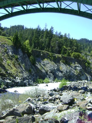 Right across the highway one may endeavor upon the steep climb up the "Bluff Creek Historic Trail." We have not attempted this yet, but some of the maps show it going all the way up to Louse Camp, along the creek. This would mean that in some spots it covers part of the old road along the creek that washed away nearly for good in the 1964 flood. It was replowed, as this was the road that Patterson and Gimlin first tried to take out during the torrential rain that followed during the evening of the day they took their famous film. The road was impassable then due to mud slides.
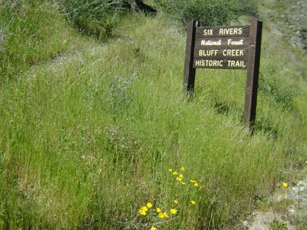
We have it on good locally-sourced word that this trail is not in actual fact "historical," but was constructed later starting at this point. The source says that the real old trail started at essentially the same spot as the old Bluff Creek Road starting point, and that Bluff Creek actually used to subsume Aikens Creek and enter the Klamath a touch farther south near where the Aikens Creek Campground now is. Strange, but true? We are looking for the maps and aerial photos that could prove this, and our source may have them for us this summer.
 After a meal at the ever-strange Orleans Mining Company Diner, complete with stuffed two-headed calf and about a thousand decorated wrought-iron frying pans on the walls, we headed up "Eyesee Road," otherwise known as the G-O Road (Gasquet-Orleans), Route 15, heading up toward the headwaters of Bluff Creek and on to Elk Valley.
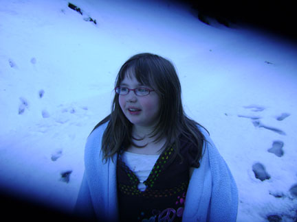
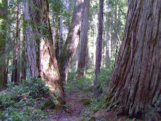
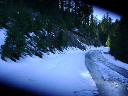
This is the road to the Patterson-Gimlin Film Site, but sorry to say, we did not make it that far. As expected, higher elevation north-facing slopes all were covered in snow. We stopped 13.5 miles up from the Orleans cut-off (just past 15N01F), which means we were only three miles from 12N12, and the "Sasquatch Road," as it was traditionally known by local loggers and road contractors. This is the way to 12N13, which passes the spur down to the P-G site and eventually lands below Notice Creek at the famed Louse Camp, site of the Pacific Northwest Expedition and so many other historical Bigfooting camp bases.
 Back to reality from dreams of summer--a 4WD vehicle could easily have made it farther up the road than we did, but count on it that there will be deeper snow banks just a ways up the road. We know this from experience. One does not wish to get stranded with an eight year old kid in tow. Given good weather one should be able to hike in to the Film Site from the gate (which will surely be locked at least another month) at the 12N13 turnoff from Cedar Camp Road (12N12) in a week or two. Full driving access will have to wait until mid-late June, we think; and that is saying nothing about rock slides and downed trees covering the road, of which there are surely many. Watch this blog for future updates--we will be in communcation with the local Forest Service rangers.
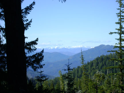 No Bigfoot tracks or sign were found in the new snow dropped just days before, given about a quarter of a mile of hiking and searching up and down the road and side trails. But wait! What are those tracks in the background behind the kid in the photo above? Could it be that a Bigfoot was following us?
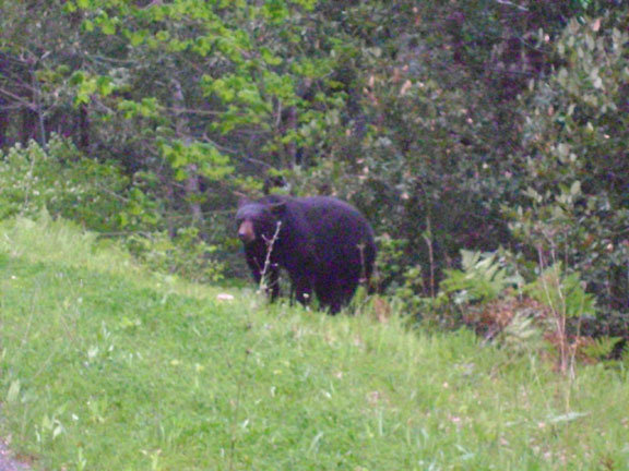
Along the way up the G-O road we had two BEAR ENCOUNTERS and one potential marten sighting, along with some squirrels here and there. The first bear sighting was special, but lo, there was another one, both juvenile yearlings. On the way down we saw two more, one a cub that was so startled when we slowly rolled up behind it that it literally leapt up into the air in shock, its limbs starting to run even before it hit the ground. If anyone ever asks you why there are no photos of roadside Bigfoot sightings just consider how difficult it is to get a photo of a bear seen by the side of the road. By the time one slows down, grabs and powers on the camera, the creature is long gone. Later, though, we found this circumstance quite decidedly reversed. Read on....
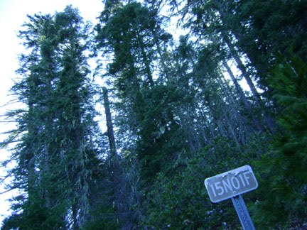
Images: Along the G-O Road. The last is a view northwards up into Oregon. Above that, the last road sign before the snow pack starts in earnest. Steven Streufert, 2010.

On the way back toward Willow Creek, however, just outside of Weitchpec, we had a bear encounter that lasted about ten minutes. Like the others along the roadside, this one was feasting on the fresh Spring grasses and berry shoots that grow prolifically after the winter breaks along the sun-exposed roadbed. We pulled up right behind this bear, about ten yards away, and it barely gave us any notice. It moved off just a few paces in caution and went back to feeding. We were able to observe and commune with it, taking numerous photographs. When a car came by along the road it hunkered down into the shadows of the trees and brush, pufffing itself up and lowering its head in threat-defense, but then just as quickly came back up to its food source.
 It was only when it finally grew irritated with the beeping sounds of our camera that it decided to move across the road. From a pile of downed tree logs on the other side it perched up high on one old fir trunk and observed us for quite a while, sniffing the air.
 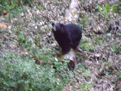 Obviously, it wanted to get back to its food, but we were not about to end this experience! Surely, even if one does not see a Bigfoot, this time of year is an amazing time to see other wildlife out in the Bluff Creek area!
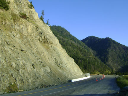
Some of you may still be concerned about the massive rock slide (see our previous blog entry) just six miles north of the Orleans Klamath River Bridge. Well, news was that it has been cleared, and lo, we proved it. The evidence of the collapse of the roadside mountain face is strewn along the pull-out along the western side of the road, and debris is littered down the cliff into the Klamath below. This is not to mention the innumerable truckloads of rock removed from the site. The road is rough from damage, but now fully navigable. It gives one a horrid feeling of uncertainty driving along this stretch, though, as many of the remaining boulders seem to be just about ready to fall on down and crush one to a bloody pulp. A permanent slide barrier is going to be built, hopefully before it is too late.

That's all we can report for now. Rest assured, Bluff Creek is alive and well, teeming with wildlife and new plant growth, and ready for a fine summer of Bigfooting.
One more bear picture, for the road...!
Read on for more Bonus Features...
**************************************************
ADDITIONAL IMAGES:

Bluff Creek Resort and company store, as it appeared in the apparent very late 1960s or early 1970s. We're guessing. Photo received from an internet source, photographer and exact date unknown. We'll be trying to confirm the date with the current owner.
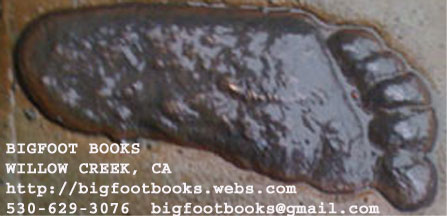
The new BIGFOOT BOOKS BOOKMARK. Just click to enlarge, and then print. It is sure to be a collector's item... yeah, right! The footprint source is Al Hodgson's 1963 Bluff and Notice Creeks track find and casting, as seen outside of the Willow Creek-China Flat Museum and Bigfoot Collection. This is the first in a planned series of bookmarks that will feature local Bigfoot history. Coming soon... JERRY CREW!
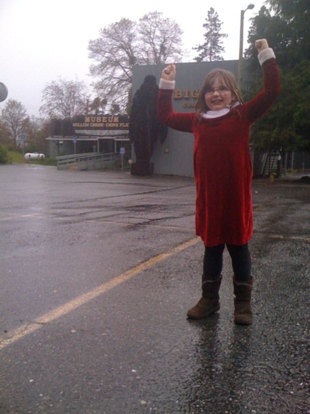 Here's DENALI out in front of the Willow Creek-China Flat Museum and Bigfoot Collection building, proving she's... BIGGER THAN BIGFOOT!!!
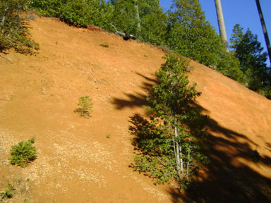 And here's one for MK Davis and the GCBRO. Look, in this image one may see the RED EARTH that predominates in parts of the Bluff Creek Region. What's that you say? "Red?" Oh my, there MUST have been a family of Sasquatch slaughtered there. And over here. And over there. And everywhere. A massacre! It's outright genocide!!! And if you think this is red, you should see the wet stuff--it's close to blood red. Enough to drive MK crazy!
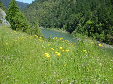 And now, just for it's own sake, a photo of the lovely springtime scene one may observe along the Klamath River. This one was taken facing north just up from the mouth of Bluff Creek. Wild California poppies, daisies, and many others are currently in bloom.
Images: All above, save for the historical Bluff Creek Resort and Patty Bigfoot enhancement, taken by Steven Streufert, 2010. CLICK ALL IMAGES TO SEE THEM ENLARGED.
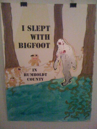
Here is a piece of art seen at Eureka's fabulous ACCIDENT GALLERY during their Ladyfest 2010 musical show. No artist label was on display, so we unfortunately can't name its creator. Perhaps the artist desires anonymity after having "slept with Bigfoot"? Perhaps the artist is afraid of those demonic "little people" in the painting? Who knows, really?
**************************************************
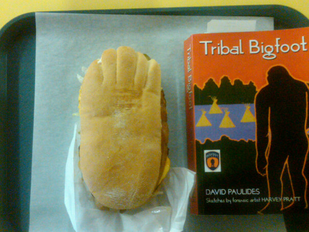
And now... THE BIGFOOT BURGER! Available at the Early Bird Restaurant, right near Bigfoot Books, this two-patty, two-third-pound-of-meat, seven-and-a-half-buck monstrosity in a foot-shaped bun should surely tide you over for a Bigfooting trip or after a hard afternoon of book shopping. Images courtesy of Bryan, of Humboldt County (last name withheld by us for privacy), who actually ate one after buying a copy of TRIBAL BIGFOOT at our shop. We, ourselves, are mostly vegetarian, and don't eat beef sandwiches.


**************************************************
 ANGRY BIGFOOT SPEAKS!
**************************************************
This weblog, website, soapbox, or whatever you call it is copyright 2010, Steven Streufert, Bigfoot Books Intergalactic. Sharing and borrowing is allowed (and often practiced by us, too) if you give full credit and citation, and a fair and nice link back to our page. SPREAD THE GOOD WORD! Thanks!