Showing posts with label PGF. Show all posts

Friday, March 30, 2012

Debris from Bluff Creek, Odds and Ends: Last Episodes of Season 2 BLUFF CREEK FILM SITE PROJECT; Bobo; Kodak Cine K-100 Camera; plus, Questions from Daniel Perez of the BF TIMES

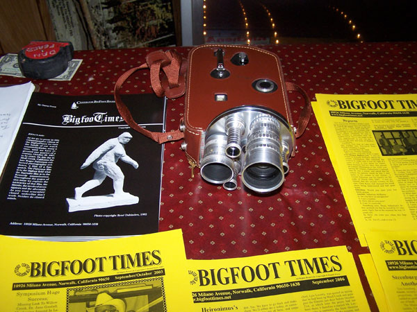
Me and My Friend, the Kodak Cine K-100,
the same camera used by Roger Patterson for the PGF.
BIGFOOT'S BLOG, 
LATE MARCH 2012 EDITION

Before the next season of Bluff Creek adventures begin, I thought I'd better gather up some of the last loose ends from the previous season's efforts. Season Two of the BLUFF CREEK FILM SITE PROJECT is now completed (view the last episodes below), and we are working on plans for a major pow-wow of new investigations once the area up there is open again. Snow on the ridges and locked road gates usually keep us out until late June, and then lock us out again in late October. Loads of new information has poured in since we proved and verified the PGF site location, some of it very odd and confounding aspects of the Bluff Creek history. We've been told that Bob Heironimus was in Willow Creek in 1965, which is just too odd to blog about without further data. The investigation continues....

*******
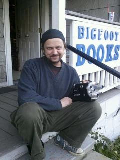
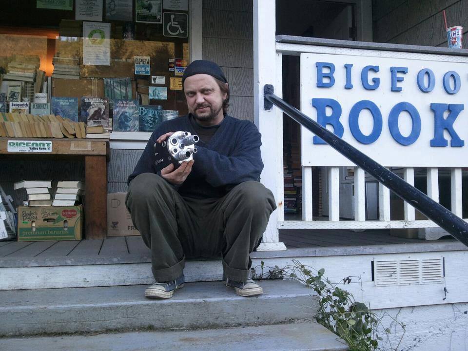
An anonymous (for now) "R.K." sent me a vintage sixties Kodak Cine K-100 16mm film camera, just like the one used by Roger Patterson in 1967. It is an identical model, save that it has a front-loaded lens turret. It is in apparently functional working order, so it may come in handy for research this summer. Here are some nifty photos of that...
The K-100 with the three-lens front turret. Patterson had the single-lens setup.
Ahm a gonna film me one a dem sum-bucks!
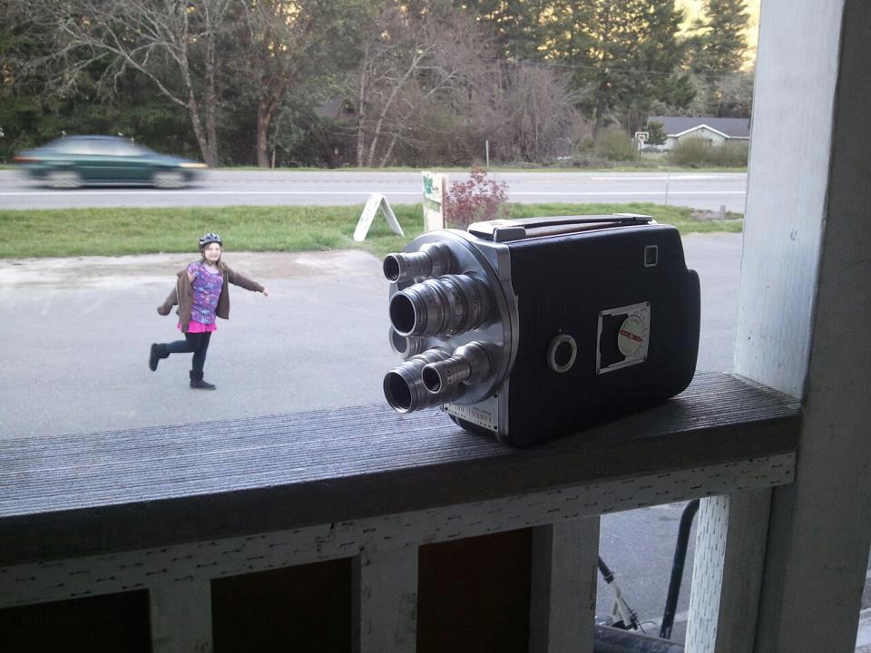
Little Bigfoot walks behind the K-100.
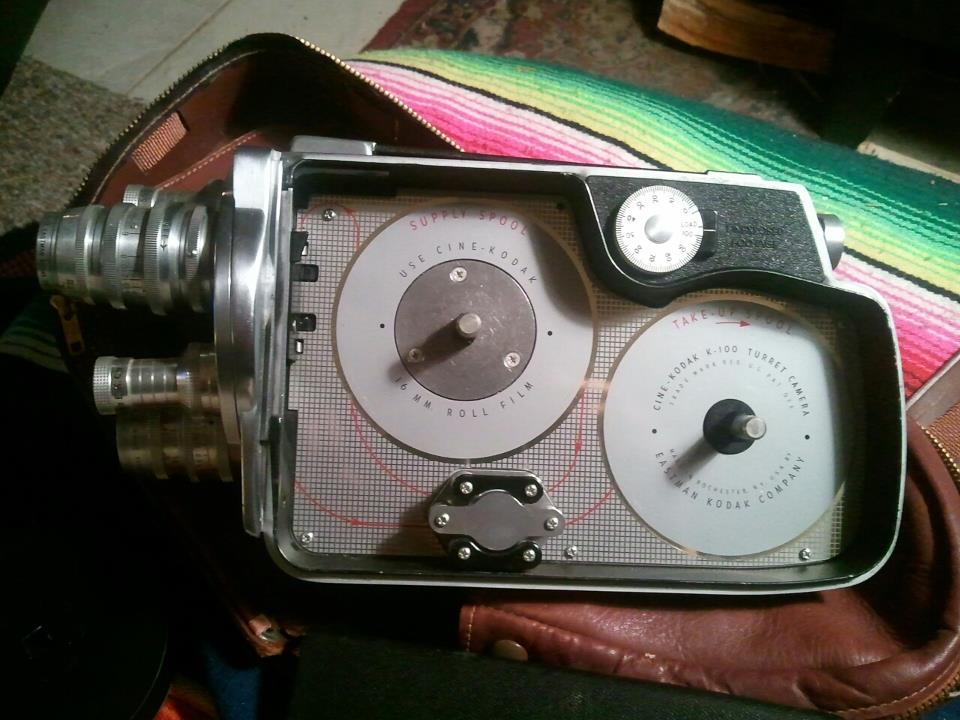
Interior of the camera. Click to Enlarge.
*******
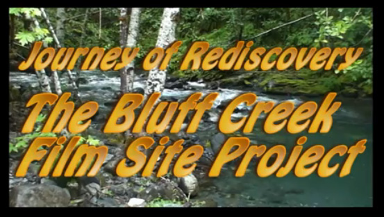
The continuing drama of the BLUFF CREEK FILM SITE PROJECT, Season Two, Episodes 63-67 
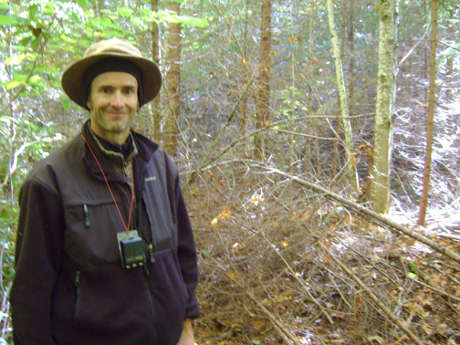
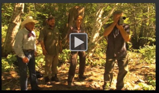
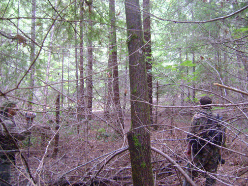
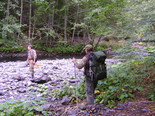
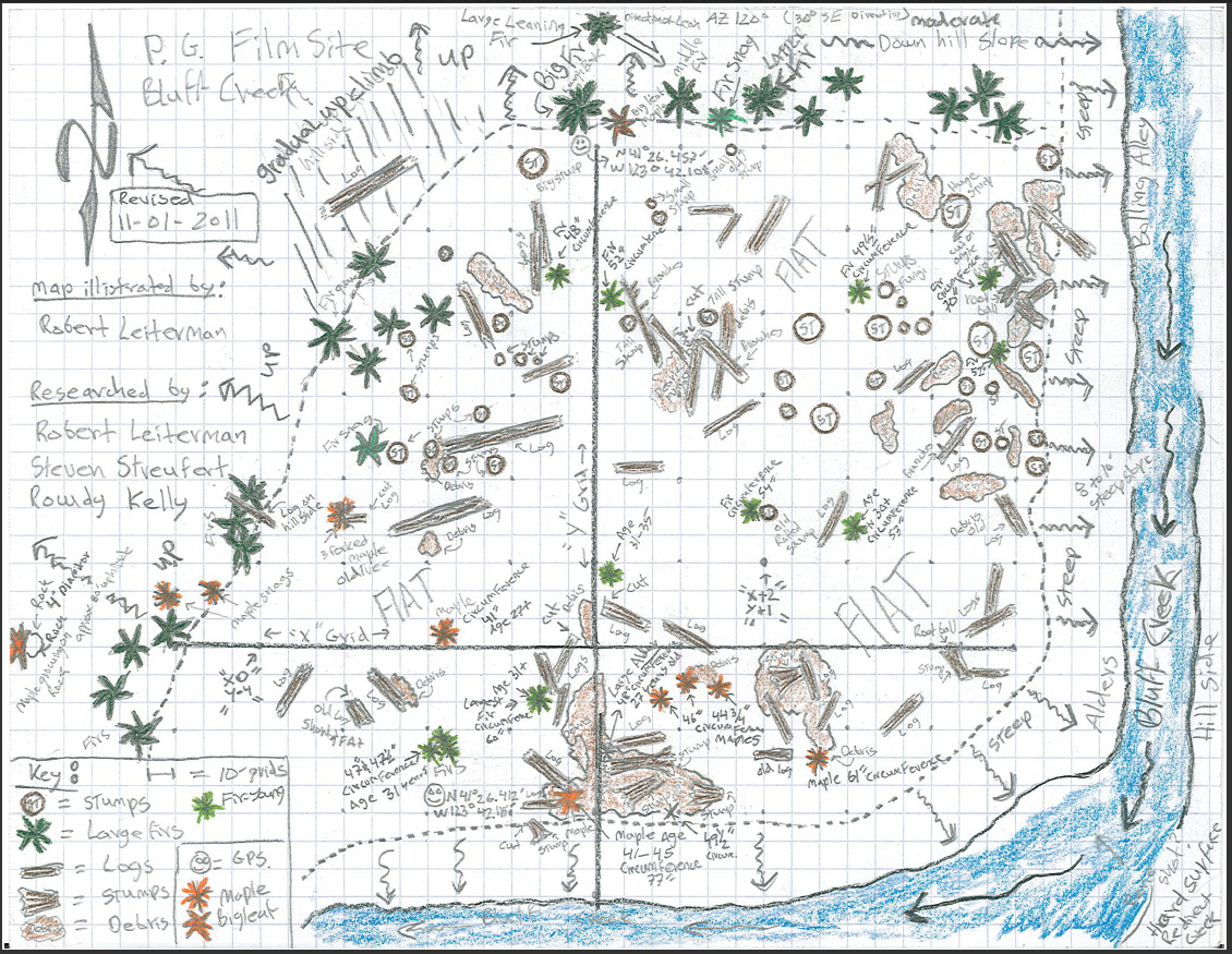
This is Season Two, brand NEW. Back to the Creek Again! Here you will find the "Checking the Grid and Site Draft Map, and Measuring the Big Trees" episode. Part 63. Check it out!
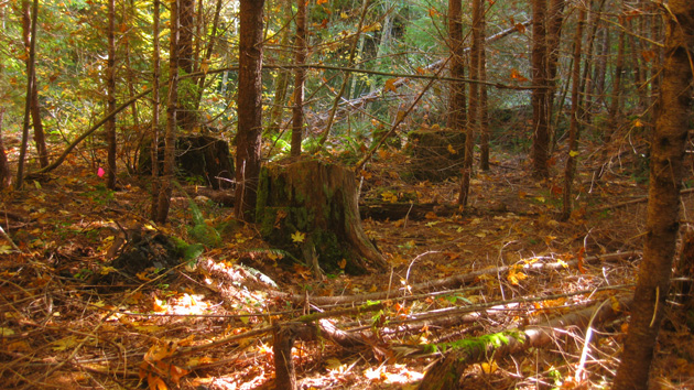
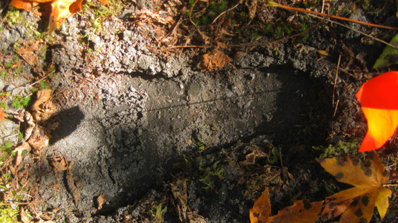
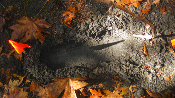
Here you will find the "Measuring the Big Trees and Making Test Footprints" episode.
Part 64. Check it out!
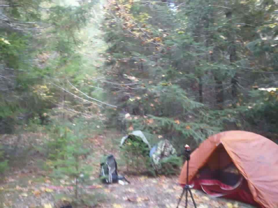
Here you will find the "Robert Survives Solo Camping on the Film Site and Does the Tree Bores" episode. Part 65. Check it out!
Here you will find the "Aftermath Discussion at the Old Bigfoot Motel" episode. 
Part 66. Check it out!
Here you will find the "Robert Interviews our Mathematician/Geologist on the Film Site Math Proof" episode. Part 67. Check it out!
*******
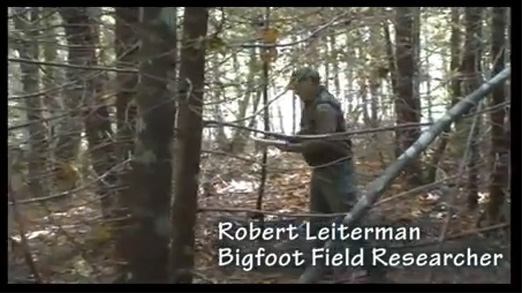
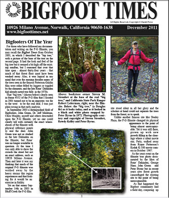
Before he awarded us the BIGFOOTERS OF THE YEAR award, Daniel Perez sent Robert Leiterman and I some questions. Here is that email interview....
QUESTIONS FROM DANIEL PEREZ, the Full Text.
(Parts of this were published between the December 2011 and January Issues of THE BIGFOOT TIMES. Click the name to visit Daniel's site and subscribe.)

Robert and Steven: some questions for a write up in the Bigfoot Times newsletter.
PEREZ: 1) Who made the decision to create The Bluff Creek Film Site Project?
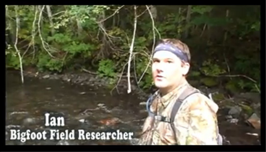
STEVE: It was Ian and I who started this research project by obsessing over small details in the history of Bluff Creek. There were a lot of unanswered questions, and many outright contradictions. This included five main opinions as to the location of the PGF site, and many more minor locations proposed or hinted at by others. As explained below, the official “Project” was started in 2010, when Robert joined us and started filming our research and investigations, and releasing the results on the BFRO YouTube page. I’ve been blogging about it, too, on BIGFOOT’S BLOG. It has been a long personal process for each of us, but our collective work took the last two summer-fall seasons, with preliminary stuff between Ian and I before that in 2009.
PEREZ: 2) When did this project begin?
STEVE: Ian and I were separately heading up to Bluff Creek in the early to mid 2000s, and began working together on this history after meeting at the Yakima Bigfoot Round-Up in 2009. In 2010 we began working with Robert, who wanted to document the process. Three summer-fall seasons, then, went into this Project. I first looked for the film site, using John Green’s sketch in his first pamphlet/booklet, in 2001. Green’s map was rather vague and imprecise. Questions lingered until I was back up there in 2007 with Cliff Barackman, James “Bobo” Fay, and others. From their opinions, guided in part by what Gimlin had said in 2003, and the marked maps found in BIGFOOT AT BLUFF CREEK, we tried to find the film site. It was a strange place, at once familiar, and yet very alien. No clear indications were found anywhere of the scenery familiar in brief glimpses in the  PGF itself. The following years were a slow and sometimes agonizing process of trying to pull the real information from the word-of-mouth and presumptuous statements made by various researchers. Ian was there in 2006, where he met Daniel Perez and Richard Henry. His outdoors and navigational experience gave rise to a parallel interest in discovering the site. Ian and I met in YakimaWashington, but were able to conveniently meet and head to Bluff Creek as he lived nearby in Redding. I’d known Leiterman for a while, and when he heard about our research his own curiosity to find the site was ignited. He became a driving force to get us to apply our research on-site, rather than just hike around and theorize.

Perez, 2007, Willow Creek. Photo by Streufert
PEREZ: 3) Who was part of the project?
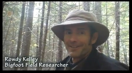
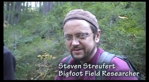
STEVE: Ian C., Steven Streufert, Robert Leiterman, with part-time participation of Rip Lyttle, and then Rowdy Kelley toward the end of it. We were aided immensely, of course, by the remaining older locals from the general Willow Creek area, like Al Hodgson and Jay Rowland, as well as many of the old-time Bigfoot researchers like John Green, Jim McClarin, Bob Gimlin… and yourself Daniel Perez, among many others.
PEREZ: 4) Many other parties claimed to know where the filmsite was but nothing bore fruit. Do you think they were doing it to attract attention to themselves rather than the subject?
STEVE: Before what I like to call the “Great Confusion of 2003" (when many major researchers along with Gimlin himself tried to find the site and could not), I think many just assumed that the site was “known.” We found, living here and having the time to try to actually find the spot, that it was NOT known. As it turned out, the spot found in BIGFOOT AT BLUFF CREEK was correct, but the trackway course was not found, nor the big trees, nor frankly any of the things actually seen in the film. The last positive ID of these features that we’ve been able to determine was made in 1983, by Thomas Steenburg, who had help from Dahinden. After this it really seems to have become overgrown and lost to time, with Green and Titmus not being able to find it at all by around 1998.

The many researchers who have made the varied claims of “their own” filmsite location seem to have suffered either the confusion of faded memories, or else a certain arrogance that their own “information” and “knowledge” were sufficient, despite a nearly total lack of verification and validation. Those like MK simply made up their own location, with no substantiation whatsoever save that the spot “felt” right to them, and they had heard some snippet or rumor that they felt must be accurate. We found, in trying to investigate this stuff, that there were MANY such snippets, and NONE of them could prove anything. What we saw was an oral history disintegrating into legend. We sought to correct that, and it truly was not easy to do. We sought to establish truth and reality, a real history, which are rare things in the field of Bigfooting, I’m sorry to say.

I have to say that the biggest enemy in this endeavor has been the presupposition of unfounded claims made by some researchers who never even bothered with proof and documentation. Just saying something is so is never enough. As in the case of MK, one false conception can lead to a thousand others following. Attention-getting? YES. It seems to be what drives Bigfooting the most, as we generally can’t seem to produce very good evidence of the phenomenon it give more weight to individual declarations, egotism, and imaginary and unsubstantiated claims to truth without real evidence. Everyone in this likes to call themselves “researchers,” but it is stunning how few of them actually bother to document and really study anything.
PEREZ: 5) Are you confident that after 40+ years you have located the exact spot?
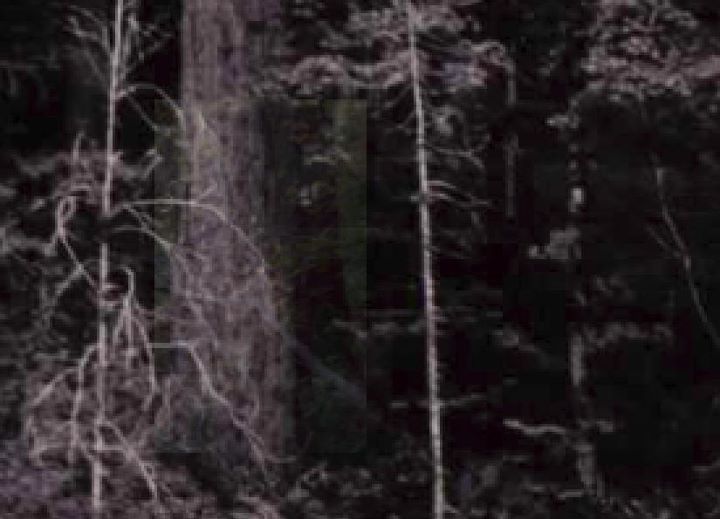
STEVE: Yes. Indeed. Well, we still have to prove it absolutely to the world. Proof, in a scientific and surveying or optical/photographic sense, is a whole other order of business. The history is ambiguous and contradictory, too. I am satisfied, though, that this is the site, and I see absolutely NO evidence for any other location we have investigated. ALL of the evidence and history, such as it is, points to this one single sandbar on the long course of the creek. There is no doubt in my mind, as I walk on the very course of the trackway on that site. It is big enough, with all the landmarks and proportions in order. Once understood, the site becomes clearly visible (conceivable, at least, though one cannot really see in the way Patterson’s camera did back then), despite these 44 years passed and new forest growth since the filming event.
PEREZ: 6) Of the team, who had that Eureka moment of pinpointing the "big tree?"
STEVE: The “Eureka” moment was really a gradual process realized as a group over a few years. It was I, Steve, who began insisting on that particular big tree and area, and seeing the sandbar and the angle of view in the film toward the “right” side of the sandbar. But I'm not claiming credit for it personally. It was group research, and no one of us alone could have brought this project to fruition. That is why we go by "BLUFF CREEK FILM SITE PROJECT."
We’d looked in that area before, but always felt that the trees were just way off too far toward the end of the film. We had decided that we would focus on that spot and do a site survey last year, but we ran out of time with the seasons and weather changing. Robert and I were even more convinced when we heard that it was Gimlin who had identified the spot of the first sighting. Ian remained skeptical, thinking the site and big trees were not big enough, and so forth.
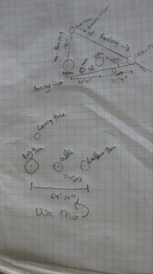
I found my way to that tree again this mid-summer (during a time when we were unable to get the group together up there), and gave it a serious new look. I had to change my whole mental image of the film site around to realize it was the correct tree in the right spot. In many ways the image in the film is an optical illusion of perspective, with a  moving subject and camera position. We had to think around “square” models such as seen in Murphy’s diorama of the site. I began pointing out that tree to the others, the biggest one down there in that general spot. Robert agreed, but reserved judgment until we could do the site survey grid. Robert was very determined to get to that level of documentation before concluding anything. Ian wasn’t able spend much time at the spot with us in the one time we were all of us together there this summer. He still has reservations, but I think we’re making a little headway convincing him.
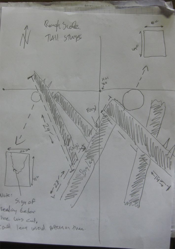
When we did our survey with Rowdy we saw things in greater depth and focus, and the landmarks began to emerge from the “jungle.” We saw the trees for the forest. So many had assumed that that area was just not big enough, but when we measured it the known film distances fit in there perfectly, with all the right pieces of the puzzle. Next to that big tree there were others in what appeared to be exactly the correct locations. When we were there as a group surveying without Ian I showed that big tree to the guys again. Rowdy then insightfully spotted the maple next to the big tree, with a slightly bent trunk. I then identified the spiky snag, which I'd never thought before could still be standing. The "ladder tree" and middle tree were obvious, once the big tree was found. The other background big tree clusters are notably similar, but we have yet to fully study and measure all of them. Measuring anything on that hillside is very difficult.
Robert gets loads of credit for conceiving of and managing the site survey. It was Robert who was most fixated on the stumps, which are other lasting features that will help prove this location with finality. Rowdy helped out in huge ways at that point, in organizing and conducting the site measurements. Rowdy, who has a degree and works in film, has already contributed many new views and analyses that hadn’t occurred to us before he got involved.
Ian’s skepticism and rationalism have been constant guards against false assumption. 
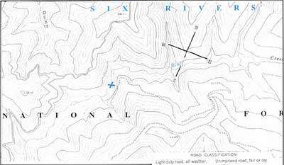
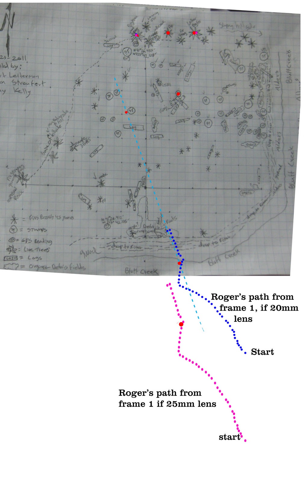
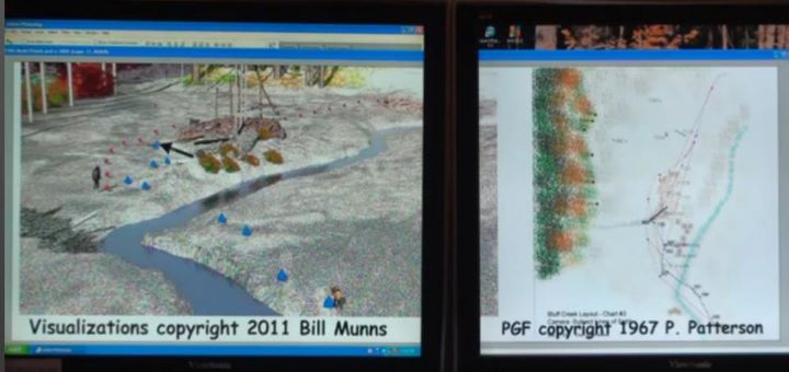
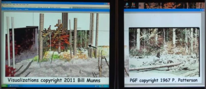
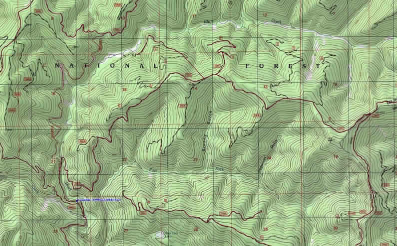
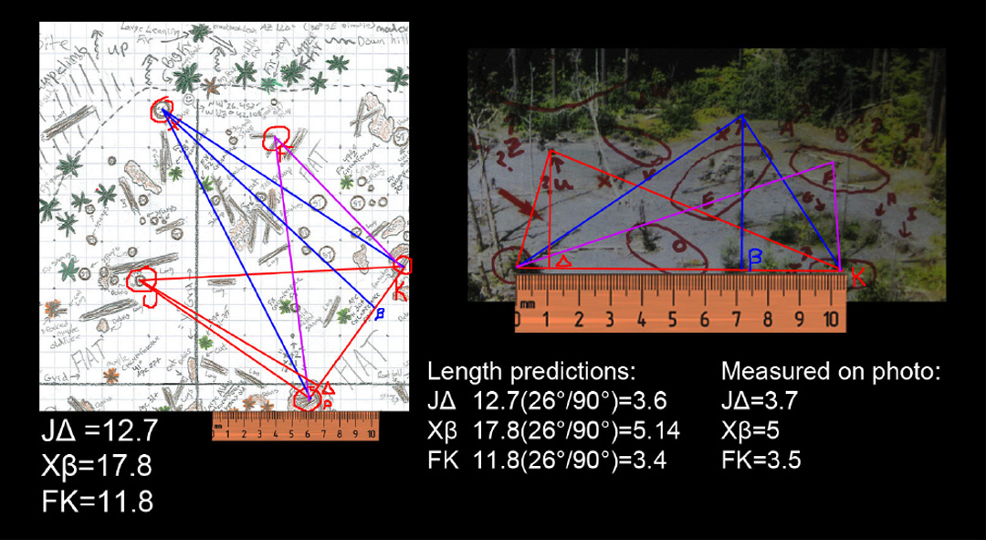
The Process: The arrow in the Perez booklet identifies the end point of the film, pointing specifically to the upper sandbar zone. Gimlin identified the crook in the creek downstream as the first sighting spot in 2003, and more decidedly this summer on site. In 2010 Perez, upon being asked to pinpoint Rene's exact mark on the map, marked this very spot. We had already ruled out all locations downstream, and focused on the upper sandbar when Gimlin arrived here. We had to try to conceive of that sandbar without the new tree growth, trying to see again what Dahinden saw in his "aerial" shot from the hillside. We realized that the big trees had to be farther toward the end of the sandbar, and that the film was shot diagonally across the apparent north orientation of the sandbar. Munns put out an animation recreating the motion of cameraman and subject within the setting, and this was instrumental in our revisualizing the site. We drew a magnetic north axis on site and found it oriented perfectly with the biggest tree there, one we'd previously thought was way too far to the "right" to be the big tree. Upon close inspection, all the other main trees were found, and in our site survey the old stumps and debris piles were amazingly still there.

PEREZ: 7) In the blog site, it is stated, "Though the proof is not officially final..." Who makes it official?
STEVE: “PROOF” cannot be had by mere photography, as the site is a totally overgrown jungle now. Each detail needed to be analyzed by itself, and put into location on our site grid map in order to be seen and understood in context. This was the real, full “Eureka” moment, when Robert finished his map. There was so much more correspondence than we’d ever imagined we’d find.
We have shared our results with Bill Munns, and he has confirmed preliminarily that we’ve gotten it correctly. We are hoping to continue this work on-site in 2012, hopefully with those who have expert knowledge in surveying, cameras and optics, not to mention geology and natural history. We have found innumerable ways in to this subject, and have had to learn much in order to be able to understand what we were seeing and finding. We are all of us amateurs, so we did our best, and at this point we are hoping that others will be able to verify our findings in a fully convincing and professional way that will leave no doubt lingering into the future.
PEREZ: 8) About how many man hours did it take to produce your quadrant map?
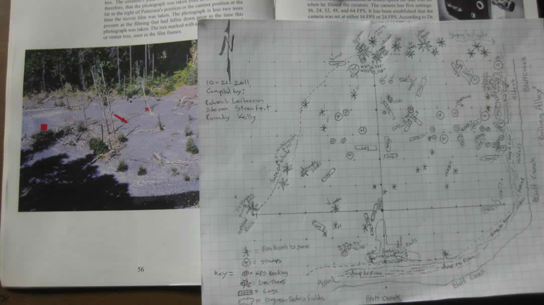
STEVE: Ask Robert about that one. We spent three days the first trip, myself one day and Robert two days the next trip, in the map/survey process. Robert spent countless hours working on the maps once he got back from the site.

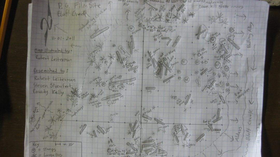
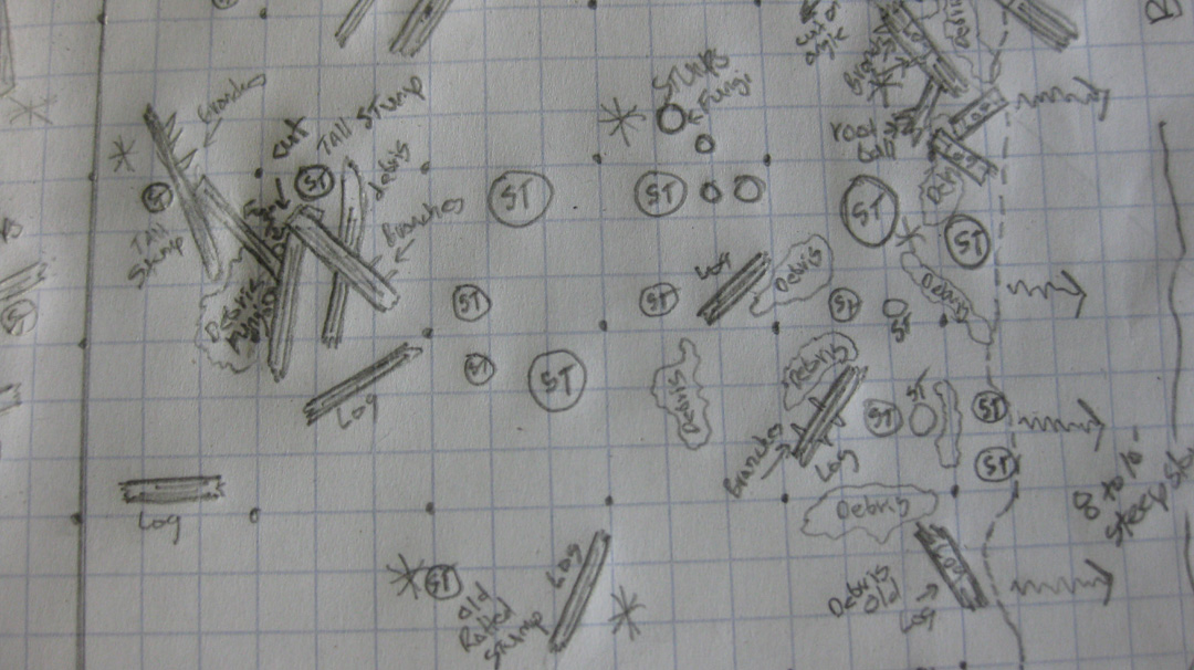
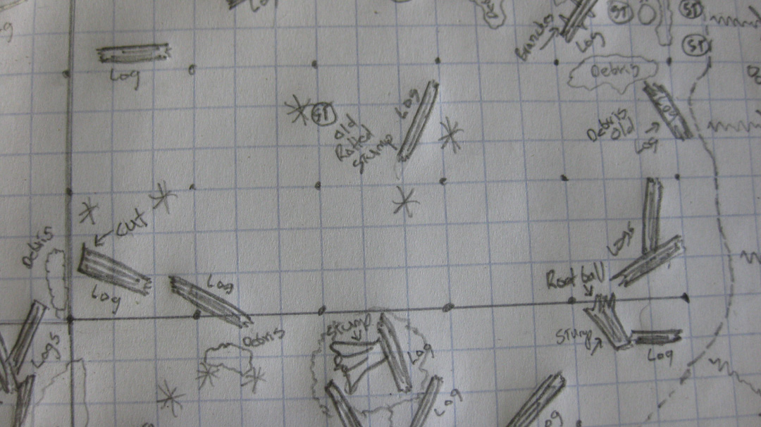
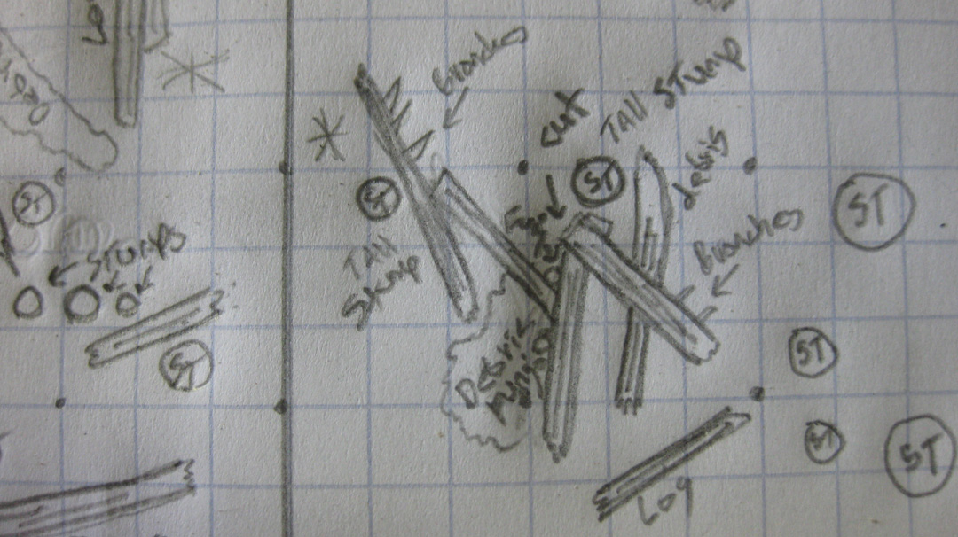
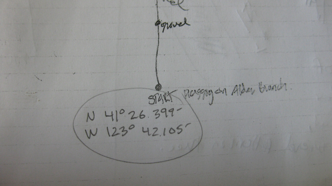
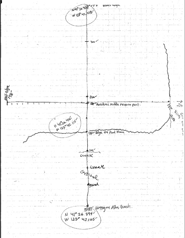
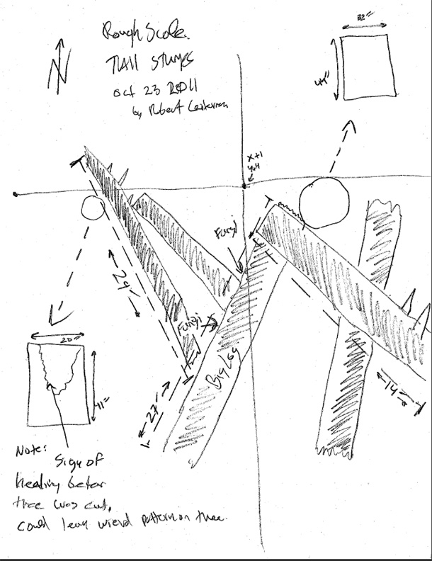
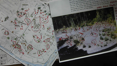
ROBERT: Daniel--Steven, Rowdy and I had spent approximately 60 man hours of actual work time on the film site gridding the gravel bar for the map during October, 2011. This included compass work, some brush clearing, tree boring (determining ages of trees), gridding and flagging the site with north/south (Y) and east/west (X) axis points and lines, also drawing in the stumps, logs, trees, debris piles and root balls (artifacts) and double-checking our data on the ground (searching/walking/confirming/correcting). See the hourly breakdown by researcher below.

October 22 nd. 2011 total combined 22.5 hours
Robert - 7.5 hours
Steven - 7.5 hours
Rowdy - 7.5 hours
October 23 rd. 2011 total combined 22.5 hours
Robert - 7.5 hours
Steven - 7.5 hours
Rowdy - 7.5 hours
October 30th 2011 total combined 9 hours.
Robert - 5.5 hours
Steven - 3.5 hours
October 31st 2011 total combined 6 hours.
Robert - 6 hours
Approximately 6 + 9 + 22.5 + 22.5 = 60 hours of field work and another few hours transferring the data to the final map.
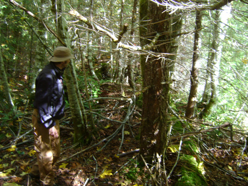
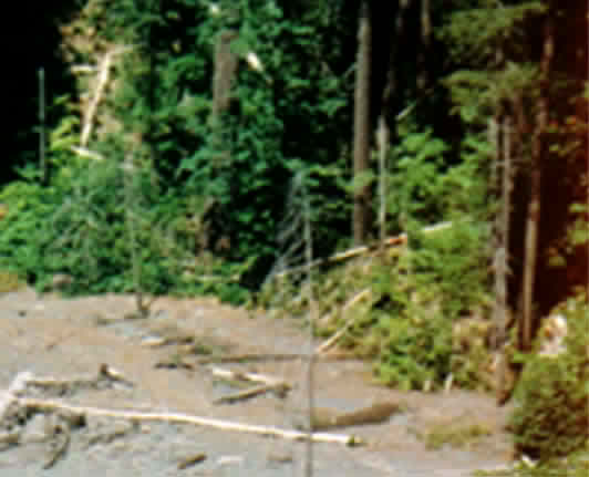
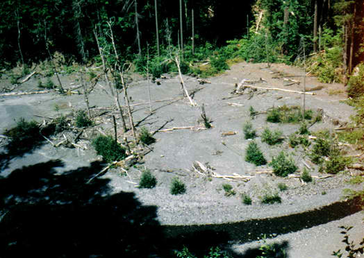
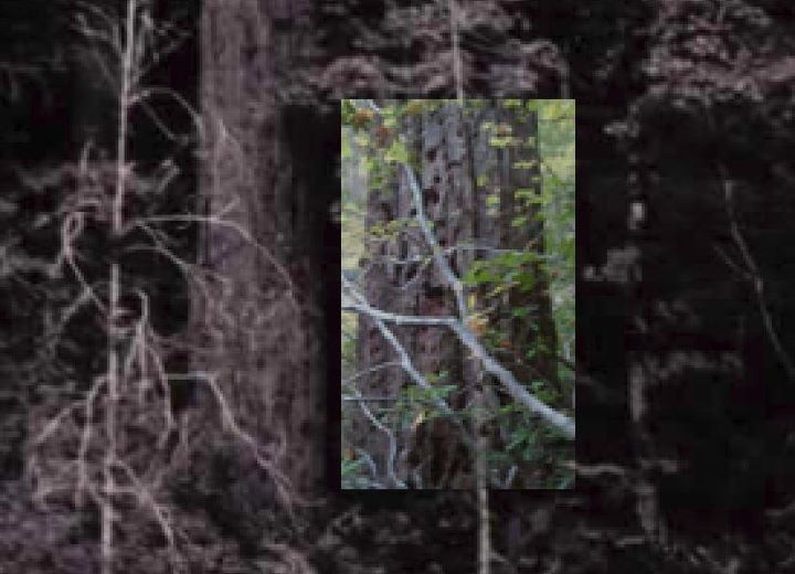
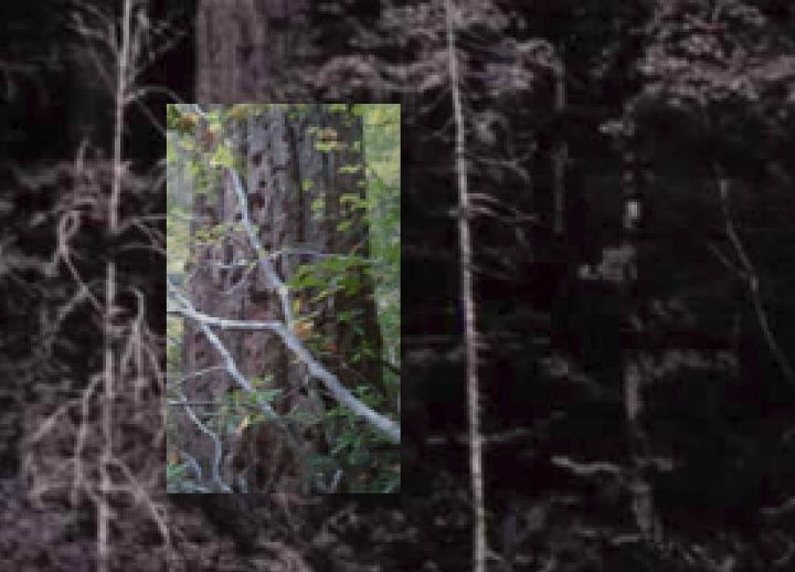
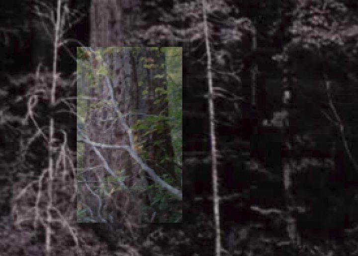
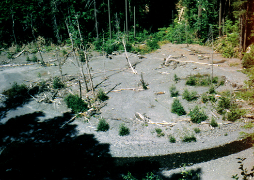
The lower bend and root balls at PGF site area.
Photo by Steven Streufert
PEREZ:  9) When I told Robert in 2007 I believe it was a waste of time to look for the filmsite because I thought it was all changed forever, you didn't buy into that idea. Was this the result of training as a forest ranger and schooling and general experience about the woods and longevity of trees?
STEVE: Leaving this one for Robert…
My comment: We knew that the geology and history of the Bluff Creek area could be understood. We sought to discover all we could that would bear upon the stories told about the events from 1958 to 1967 that involved Bigfoot. What we saw in the creek area were the remnants of the 1964 Flood. We then understood that the sandbar, established by that 500-year event (or whatever it was) should still be there in some form. We found no evidence of logging having been done since 1965-66 salvage work post-Flood. Hence, we refuted the things people had been saying, such as: “It’s all been washed away,” or “The trees should be stumps now.” We showed that with persistence reality may be discovered and history documented. We showed that it is idiotic to just assume things as these people did, without any clear evidence for such assumptions.
We were determined not to just say, for instance, that we knew how to get to the Los Angeles urban area. We wanted to get to Norwalk, and then to a certain address, and eventually find the spot of a specific location, like finding Daniel Perez’ house there. Many said that it could not be found, or that it did not matter; but we found many clues along the way, and it was fun playing Sherlock Holmes with these Bigfoot-related mysteries.
ROBERT:  Steven covered some good stuff already. I will add to it. I find that few people have the patience to get down and get dirty in the field. Very few of us have the ability or take the time to double-check what others say about things. Sometimes we find it easier to assume the obvious and go with the flow, giving some statements credence. If three people agree it's got to be fact right? And let’s face it, we’re no longer a society of outdoorsmen and women whose very existence had depended on the ability to read the signs and predict the weather.

As a park ranger, spending time in the forest is my profession. Being able to read my surroundings can be an essential skill. Though not all park rangers live and work in forests, I do. I spend a considerable amount of time in the outdoors and have taken it upon myself to feel more comfortable in them. I have also tried to better understand my home area.

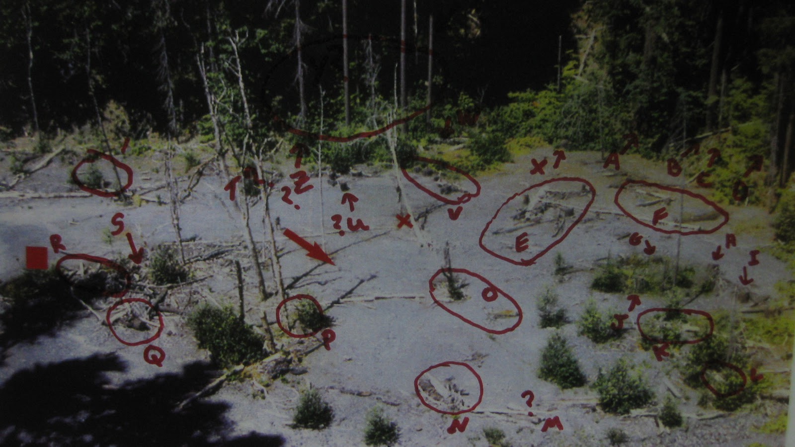
Back to the film site.... I realize a lot of change can happen on a gravel bar in 44 years, but I also realize that certain landscape features like trees, stumps and logs will take time to totally disappear. Much of that is dependent on insects, fungi, the weather, topography and other factors. Nature has its way of making sure of that. If there were once big trees, then there should be the remains of either the big trees themselves or stumps, and some stumps can hang around for a good bit of time. If the downed logs and stumps were no longer visible, then there should be debris pile remains in their place, possibly in the form of logs and stumps. Stumps last longer than most logs. Different tree species break down faster than others. As an example, alders and cottonwoods will break down faster than firs. Determining the age of trees on the floodplain could also help us see the forest despite the 40-year-old newer trees. For the most part, the positions of the artifacts (logs, stumps, trees) shouldn’t change unless they were washed away, buried or hauled away by salvage loggers. All we needed were clear pictures, a good aerial view of the P.G. Film Site (compliments of Rene Dahinden's 1971 overview) to match some artifacts, as well as patience and time. With the photographs in hand, and a little determination, we were bound to find something. As it was, we did find something... a whole lot of somethings that looked an awful lot like the Rene 1971 overview.

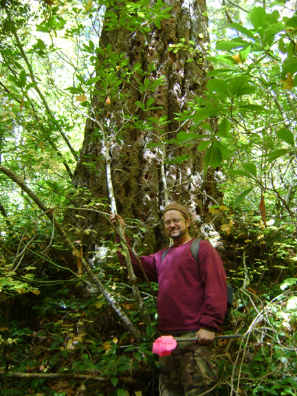
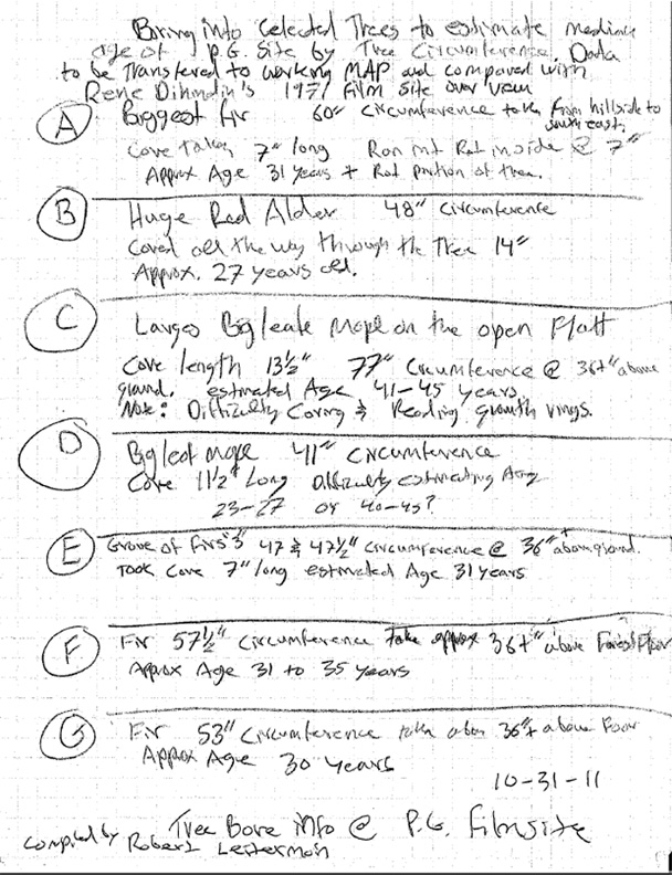
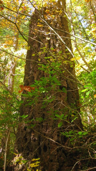
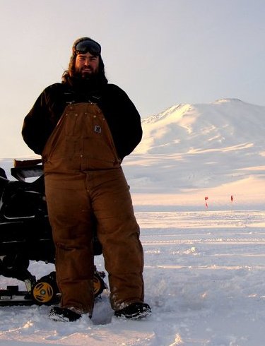
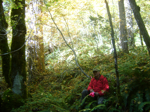
PEREZ: 10) The big tree, what is the present diameter and circumference of it? And is it in your opinion still the largest tree in that immediate vicinity?
STEVE: It is the largest tree in the upper sandbar area. Downstream from there we found two other trees of that huge size, but they are of course in the wrong places. Unfortunately, time and the mass of things to do somehow overwhelmed us, and we didn’t get to measure the diameter of the tree. You can see in the photo of it with me in front how large it is. I’m standing right at its base, so rough measurements of my size and the tree behind me may be made. I’d say the tree is about five feet in diameter. It is an old growth Douglas fir, of the top size found in that climate, soil and terrain, but it certainly is not the largest fir I’ve ever seen. I think it is big enough indeed to be the one seen in the film. Hopefully an optical expert like Munns with be able to tell us this with certainty, based upon our measurements.
PEREZ: 11) Was the Eureka moment derived by association of other items that made a match from 40+ years ago?
STEVE: That is explained above mostly. All the factors of history that we could find played into this. We talked to all the witnesses of the site and area that we could find, and investigated some six miles of the creek watershed. We were frankly astonished to find how much STILL remained, however much others assumed it would all be changed. I mean, stumps and big trees, yes, were there, but we also found the debris piles rotting away but still in the same places. We have over two dozen clearly identifiable matching features outlined in Robert’s comparison map done with the 1971 Dahinden “aerial” photo. And there are many more possible ID points to be found with further analyses. Even the empty spaces on the sandbar are positive data points, as it is quite unlikely up there for something NOT to grow on a spot. Hence, if there is no stump or tree over 40 years old on the site now, and the same state existed in 1967, that is another correlation and correspondence. Finding the big tree was great, but it was astounding to find the other trees along the line, one by one, and to see that their layout was a perfect match for what is seen behind the creature in the 1967 film.
PEREZ: 12)  Did the two of you have a physical advantage over the Bigfoot community because you live geographically closer to the area than most others?
STEVE: Of course! For some it is a lifetime Mecca journey to get up there. For me it is an easy day trip. Hence, we were able to return again and again to answer lingering questions and to explore new information, and finally to check and re-check data.
PEREZ: 13) To Robert, are you surprised that this area, once relatively clear, is an "overgrown jungle" today?
ROBERT: You mean young temperate forest? No. We’re talking successional growth, part of the natural cycle. The flood waters gave that bend in the river a clean slate. Sunlight, nutrients, organic debris for shelter against the harsh elements, the proximity of water, all of these were factors. The new layer of sand and silt was a seed bed for the successional plants. After they established themselves, the trees were soon to follow. What we’re looking at now is a forest reestablishing itself in a prior habitat right in the middle of the P.G. Film Site.

PEREZ: 14) Do you think you ruffled feathers with discounting Murphy's location and his physical filmsite model?
STEVE: Well, when I questioned Christopher Murphy about this stuff he was always open and helpful. When I contacted him before his Sasquatch Summit presentation he listened to my points without defensiveness, and then changed his talk to reflect parts of our research. He did a very fine job in making his site model diorama, but we found it ultimately limiting as it created a predisposition to view the perspective and motion in the film wrongly. It was just a recreation of frame 352, based on Dahinden’s measurements. When we cracked our minds out of those shells we were able to look at the actual locations in new ways.
The site location found in Murphy’s books was based on only one visit there in 2003, for only a few hours, so he cannot really be blamed for getting the location wrongly. It was really pretty close, but inexact. In any case, he was getting cues from others there, so any confusion in his books or internet statements only reflects the difficulties that PGF site location research faced at that point. It is not his fault, really, and he’s been a gentleman about it… unlike many others who have acted as if this were a PERSONAL ISSUE. It is not, and it should not be. It is about facts, not egos.
PEREZ: 15) Where many of the stumps noted in the original P-G film and noted by later researchers still there?
STEVE: I’ve answered this above. We need to get someone with high-level optical photo-analysis skills and software to look at this, but from Robert’s comparison work we’ve shown, I think, a level of correspondence that goes way beyond randomness and is in the highest level of certainty. This is just eyeball work, though, done while constantly having to adjust one’s assumptions trying to approximate the true film perspective in comparison with the site map and overview hillside photo. It isn’t easy to do. As far as we can tell at this point essentially ALL of the bigger features of the film are still present there, and are to be found in more or less exactly the same position and similar condition now as they were in 1967.
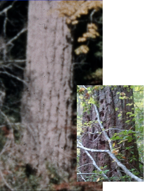
PEREZ: 16) Did the woodpecker holes that Peter Byrne said where there in 1972 on the big tree something that strengthened the case for the correct site?
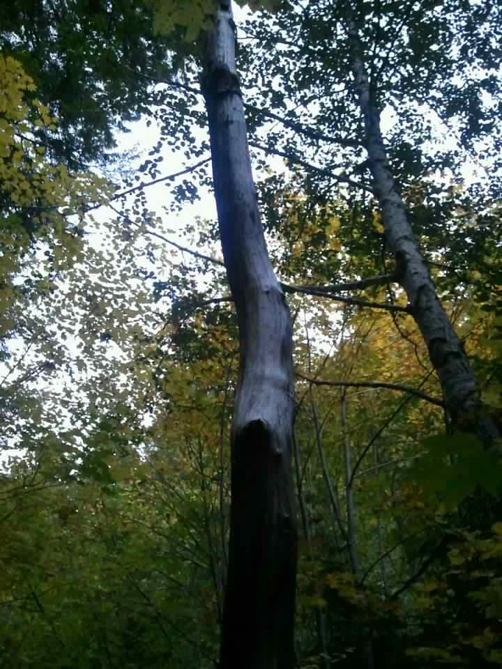
STEVE: Well, Byrne’s memory of how to get to the film site seems to have faded over the years since he was there and it was recognizable. We know from his photos that he was there on the right spot. He took the best photos documenting the site. But since then he has been taking people or guiding them to the spot right at the road bottom, at the bat boxes. This is wholly implausible, much like the MK Davis location, for near-total lack of corresponding features and a landscape that is totally different from that in the film itself. One thing he DID remember was the pock-marked bark of the Big Tree. This is EXACTLY what we found when we identified the tree. Apparently these are holes made by woodpeckers trying to get at bark beetles and other insects infesting the tree. This may indicate weakness in the tree, so it may be quite aged and on its way out sometime in the not too distant future.
We are going to try to get a core-bore of the tree’s rings next summer, and of course this time we will have the required two people and time enough to get a diameter and circumference measurement of it. That is the funniest aspect of this research: just as we think we’ve discovered something or the solution to some mystery, we find that a dozen new avenues of research open up requiring further investigation. Something tells me this Project is not over, and will continue on for many more years.
One thing I’d like to say here is that Bob Gimlin was RIGHT. After all the researchers had become lost and confused, Bob, who had only been there once before 2003, was able to re-identify the site. This is a real kick in the pants of those who constantly want to say that Gimlin has poor memory, or that he is confabulating. ALL ALONG THE WAY we found that Gimlin’s accounts of the locality, the scene of the filming event, and the features found down in that creekbed were essentially CORRECT.
We have to give credit to Rene Dahinden, especially, as it was his memory and research dedication that were preserved in BIGFOOT AT BLUFF CREEK. To you, too, Daniel, we are very grateful in that you actually bothered to document that recollection before the site was lost entirely to time. The clues preserved added up to enough for us to find the site again.

PEREZ: Anyway, those are my questions. Should you have additional comments, just jot them down as I would like to go to press with this soon.  Best, Daniel Perez
Daniels 2007 table at the Willow Creek PGF 40th Celebration Conference.
There in the middle is Daniel's K-100 Kodak movie camera, very similar to ours.
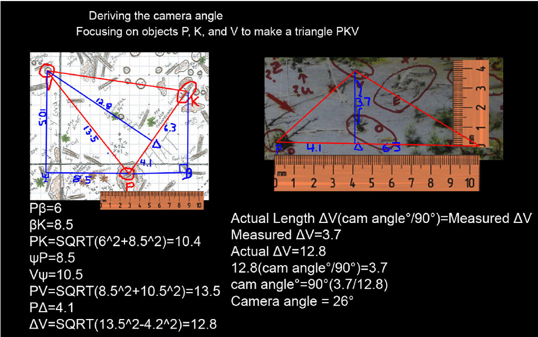
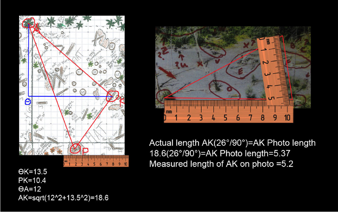
We had NO idea that he was thinking of giving us the "Oscar" of Bigfooting at the point of this interview. Do keep in mind that this was done before we had final mathematical confirmation of the site geometry. We have that now, such that we now have absolute proof that we have found the correct location. What will follow is further measurement and hopefully more useful perspective on the film itself, and its strange, hairy subject.
*******
Recently Bobo, from FINDING BIGFOOT, stopped by BIGFOOT BOOKS. Though he is a friend, I couldn't resist getting him to sign a promotional card for the show for display in my shop. Here it is:
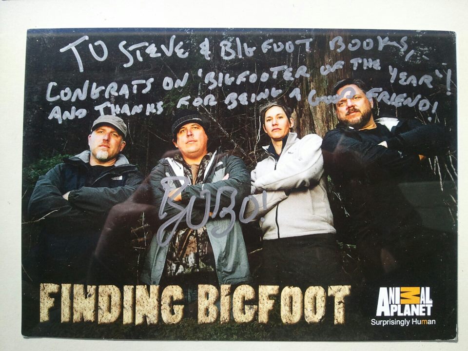
James "Bobo" Fay signed this card for Bigfoot Books.
Kids visiting the shop LOVE this thing, as they love the Bobes.
Unfortunately, Bobo was recently mauled by a Bigfoot on The Soup, but somehow survived to continue filming episodes of Season Three of the show. He is in Louisiana now, and we have word that they are heading to Australia for the Yowie, and to Southeast Asia as well. Wow! Here is the video of the attack:


And listen to a podcast episode from SAVAGE HENRY, a Humboldt humor magazine, to hear the "real" Bobo, complete with drinking games, here:  Episode 10 of SHIT Talkin'.

Until next time, SEE YA!
****************************************************
ANGRY BIGFOOT SPEAKS! 

Me Mute.
No Me No Speak.

****************************************************
This blog is copyright and all that jazz, save for occasional small elements borrowed for "research" and information or satirical purposes only, 2007-2012, Bigfoot Books and Steven Streufert. Borrowings for non-commercial purposes will be tolerated without the revenge of Angry Bigfoot, if citation and a kindly web-link are  given, preferably after contacting us and saying, Hello, like a normal person would before taking a cup of salt. No serious rip-offs of our material for vulgar commercial gain will be tolerated without major BF stomping action coming down on you, hu-man. 

Wednesday, January 25, 2012

PGF BIGFOOT FILM SITE MATHEMATICALLY PROVEN, plus More Season Two BLUFF CREEK FILM SITE PROJECT Videos

BIGFOOT'S BLOG
Late January 2012 Edition

YES ANOTHER BLUFF CREEK MEGA-ISSUE

Well, the PROOF is in, now without the slightest doubt: The PGF Site has been completely verified. Find below a mathematical proof displaying the correspondence between our site map of the location as it is today, and the 1971 Rene Dahinden "aerial" shot. This proof adjusted camera angle and compared prominent lasting landmarks using trigonometry and geometry. It was done by a practicing geologist. The conclusion?:

"Overall the geometry of Robert Leiterman, Rowdy Kelley, and Steven Streufert’s survey is a perfect match with the photo taken by Rene Dahinden of the Patterson-Gimlin film site. It's nice to see some actual hard science being applied to the field. The survey was really well done. It made it fairly easy to get accurate numbers. Now all we need is the DNA project to prove these things are real. :-)"
The "Big Tree" hiding in the new "jungle" of Bluff Creek.
Photo by Steven Streufert, October 2011.
Documentation will continue next summer, but for now this should be pretty much the last major Bluff Creek blog entry here until then. A few more episodes of the video project will appear in the near future, along with an interview being planned with our mathematician, geologist Jamie Snowhorse.

Join Coalition for Reason, Science,
Satire and Sanity in Bigfoot Research
I'm hoping to move on to a bunch of other topics that have been brewing in the background (for me) while taking up all of the Bigfooting world's time and attention in hopeless waiting and conclusion jumping--that's right, Bigfoot MindSpeak, DNA, ETs and UFOs, and BS. The latter, we hope you know, stands for "BlobSquatches," and many other things in the "Bigfoot Community."

This entry has below the next series of Season Two of the BLUFF CREEK FILM SITE PROJECT VIDEOS, now up over sixty entries. Check them out, Videos 55-62.
Click the link above to view them all on YouTube in descending chronological order. Thanks to the BFRO for hosting it on their BFRO-VIDEOS account.

Now, on to our main feature. As luck would have it, a fellow wandered into my bookstore one day. He lives in a  very woodsy area down in the redwoods, and his wife works there, so he has developed some interest in Bigfoot topics. It just also happened that he was a qualified Geologist, capable of doing  mathematical analyses of terrain and locations. I told him about our Bluff Creek PGF project, and he was fascinated. Herein we will use his pseudonym for his last name, for privacy.
*******
Comparing the PG Site Survey with the Dahinden "Aerial" Photo.
by Jamie Snowhorse
Jamie Snowhorse who graciously did this
proof for the sake of Bigfooting history.
Out of all of the evidence for the existence of Bigfoot none is more compelling than the Patterson-Gimlin film. The film is the most studied and analyzed piece of evidence in the Bigfoot community. At face-value it is either a hoaxed video of a man in a suit or an actual creature. Over the years the original location has been highly debated with many different “X”s on the map and none seemed to fit perfectly. Only recently has the newest and most promising suspected location been surveyed and mapped with accuracy. The newly suspected site was surveyed by researchers Robert Leiterman, Steven Streufert, Ian C. and Rowdy Kelley in an attempt to put an end to the controversy. Over the years the site had become overgrown and was subject to hydrologic processes that eroded away at the adjacent streambed. The gravel bar in the film is now meters above the meandering creek. And 40 years of weathering has altered the gravel bar beyond immediate recognition. A photo taken by Rene Dahinden on the hillside opposite the creek shows an aerial view of the original film site. This photo clearly shows the same gravel bar where the PG film was taken. In the photo there are many distinguishing objects that would appear in a survey of the area. These objects are durable and static enough to withstand the test of time and maintain their original positions. The best objects to use as survey monuments are trees and stumps because they are immovable and their positions can be easily surveyed. The photo serves as an accurate record of the film site and It’s monuments. The survey of the suspected site by the researchers is mapped on a two dimensional plane consisting of an X,Y grid with ten foot spacing. The survey is accurate enough to trigonometrically determine distances between objects with an accuracy of a couple feet. It clearly shows the stream bed and sand slope of the evolved creek. The orientation of the creek and the overall geometry of the survey gives the impression of a direct match; that the survey of the suspected site is an accurate survey of the original Patterson Gimlin film site. Even though the site gives the impression that it is a match with the original survey site, further mathematical comparison is needed.
The PGF Site as it is today. Map by Robert Leiterman, based upon research
and survey work by Streufert, Leiterman, Rowdy Kelley and Ian C.
Copyright. Research Purposes Only. CLICK TO ENLARGE.
The survey site and the Dahinden photo can be compared geometrically to prove that they are a match. And the first step in that process is to determine the angle of the camera of the Dahinden photo. To do this, a line is drawn between two monuments in the photo. For ease of calculation this line should be perpendicular to the camera and be significant in distance. A line between monuments marked P and K is suitable.This is the line all calculations will be based on. A Third monument should then be selected to complete a triangle between them. The same triangle should be drawn on the site survey between the same monuments. Now that there are two triangles to compare, the actual distances between the monuments in the survey are measured. For an accurate comparison and to double check the trigonometry a calibrated ruler is needed. For the site survey this should be calibrated to the grids set out on the graph. For the photo the ruler should be calibrated so that the actual distance of line PK should be marked on the corresponding line on the photo and the ruler should be stretched to fit (in this case 10.4x10 feet or just 10.4).
The 1971 Rene Dahinden "Aerial" Photo of the PGF Site.
Next the actual length of the sides of the triangle in the survey are trigonometrically derived. Then on the triangle in the photo, a line is drawn from monument V down to line PK forming two right triangles with respective 90 degree angles. This line should form a ray to the camera. This intersection is labeled Delta or “Δ” . Now using the calibrated ruler, the length of lines VΔ, ΔP, and ΔK are measured. The length of line ΔP should be transferred to it’s corresponding position on the survey to exact the location of point Δ. Then a line is drawn from point Δ to monument V to make a triangle that corresponds to photo. These triangles can then be compared and a camera angle derived. The equation used was:

Length(camera angle°/90°)=Measured length on photo

With this equation, an approximation of the camera angle is derived. Therefore, if the actual length of line ΔV is 12.8 and the measured length is 3.7 then the approximation of the camera angle is about 26 degrees. This camera angle can then be used to find objects seen in the photo and objects documented in the survey. If the monument’s actual position corresponds with the measured position on the photo then the survey location and the photo location are a match.
Proof Diagram 1: Camera Angle Comparison.
CLICK TO ENLARGE AND READ.
Now that the camera angle has been derived, it is used to predict lengths that would appear in the photo.
Proof Diagram 2: Landmark Comparison.
CLICK TO ENLARGE AND READ
Based on a camera angle of 26 degrees the prediction of the length of line AK in the photo at 5.37. When the photo is measured with a calibrated ruler the measured value is about 5.2 which is very close... within 2 feet. This proves that the geometry in the survey correctly matches the geometry of the photo. Even more objects can be compared this way to determine their corresponding locations. It is easiest to use the same calibrated line PK to base the trigonometry off of. Next, the position of monuments U, X, and F are exacted. Their positions were verified with an accuracy of about two feet.
Proof Diagram 3: Further Triangulation.
CLICK TO ENLARGE AND READ
Overall the geometry of the survey is a perfect match with the photo taken by Rene Dahinden of the Patterson-Gimlin film site. From this survey, accurate positions in the film of the alleged creature can be exacted which could prove to be useful to determine further information about the film and it’s subject.

Jamie Snowhorse, snowhorse420@gmail.com
Geology student at Humboldt State University, Participant in the US Antarctic program
BRIEF BIO:
"I'm a geology student at HSU. I Work for the US Antarctic program. I live in Orick and maintain a small network of trail cameras around the national park. I'm a geology and science enthusiast. I'm also a skeptic and freethinker. I could come up with more but I'd have to do some serious introspection..."
Above, Leiterman's comparative marks on the Dahinden photo and the
2011 Site Map. No, the red circles are not "blobsquatches."
UNIQUE WORK HEREIN IS COPYRIGHT, FOR RESEARCH PURPOSES ONLY.
*******
THE BLUFF CREEK FILM SITE PROJECT, Current Members and NEW Videos
Rowdy, Film Producer, Adventurer, the most recent member
of our group, whom we met when he was working for
Animal Planet during the local FINDING BIGFOOT filming.
Me, you probably know me all too well.
Bigfoot nerdiness started this PGF obsession, but
at least it came to something REAL in the end.
Robert, State Parks Ranger in the Redwoods,
long-suffering videographer and video editor, he is the one
who forced Ian and me to actually document this stuff.
Ian C., in partial retirement, well OK, total Bigfoot retirement, at least for now.
Ian was a founding member,along with myself, of this obsessive  pursuit.
We still don't know if he has seen the site geometry proof yet. Last we heard
he had had enough of California and gotten lost in the mountains of Virginia.
*******
If there is going to be a BIGFOOTERS OF THE YEAR award, it should go to all four of us, not just Robert and me. Thank you to Daniel Perez and BIGFOOT TIMES for the honor.

READ A FREE ISSUE OF THE NEWSLETTER Containing the Bigfooters of the Year Award on our Bluff Creek PGF site research HERE.
Yep, we're not bragging. We just want to share the information, as always.

******* 
Click on the player boxes below to view the videos. If that isn't good enough for you, right-click on them to open in another window.

The continuing drama of the BLUFF CREEK FILM SITE PROJECT.
This is Season Two, brand NEW. Back to the Creek Again! Here you will find the "Discussion at the First Sighting Spot" episode. Part 55. Check it out!
The continuing drama of the BLUFF CREEK FILM SITE PROJECT. This is Season Two, brand NEW. Back to the Creek Again! Here you will find the "Where did Bobo Walk? and Start of the Site Survey" episode. Part 56.
The continuing drama of the BLUFF CREEK FILM SITE PROJECT. This is Season Two, brand NEW. Back to the Creek Again! Here you will find the "PGF Site Survey in Action" episode. Part 57.
The continuing drama of the BLUFF CREEK FILM SITE PROJECT. This is Season Two, brand NEW. Back to the Creek Again! Here you will find the "Stomping Around in the Bluff Creek Jungle" episode. Part 58.
The continuing drama of the BLUFF CREEK FILM SITE PROJECT. This is Season Two, brand NEW. Back to the Creek Again! Here you will find the "Dog Barks at Bigfoot while the Guys Analyze Trees and Cross the Axis" episode. Part 59.
The continuing drama of the BLUFF CREEK FILM SITE PROJECT. This is Season Two, brand NEW. Back to the Creek Again! Here you will find the "Surveying the Stumps Walkthrough and Censored Daniel Perez Photo" episode. Part 60. (Believe It or Not)
The continuing drama of the BLUFF CREEK FILM SITE PROJECT.
This is Season Two, brand NEW. Back to the Creek Again! Here you will find the "Pacing the Grid Layout and Marking the Stumps and Debris Piles" episode. Part 61.
The continuing drama of the BLUFF CREEK FILM SITE PROJECT.
This is Season Two, brand NEW. Here you will find the "Marking the Grid, Big Trees, and There You Have It, Folks, The Patterson-Gimlin Film Site" episode. Part 62.

WATCH FOR THE LAST FEW SEASON TWO VIDEOS COMING YOUR WAY SOON.
We'll be back in Summer 2012 with more, and probably More....

****************************************************
ANGRY BIGFOOT SPEAKS!

What can me say? I show hu-man guys to film site many time, they just no see. Now they get award, and what I get? Bunch of survey flags on my home turf. It not funny. When Bigfoot get award? I the reason you all out there on snipe hunt. Me make you famous on hu-man TV, and I not even get cameo role? I start think again go back to eat hu-man and dog, be monster again and not care. No more Mr. Nice Bigfoot, me say.
****************************************************
This blog is copyright and all that jazz, save for occasional small elements borrowed for "research" and information or satirical purposes only, 2011-2012, Bigfoot Books and Steven Streufert. Borrowings for non-commercial purposes will be tolerated without the revenge of Angry Bigfoot, if notification, credit, citation and a kindly web-link are given, preferably after contacting us and saying, Hello, like a normal person would before taking a cup of salt. No serious rip-offs of our material for vulgar commercial gain will be tolerated without major BF stomping action coming down on you, hu-man.

Saturday, December 17, 2011

Bluff Creek Film Site Project, Journey of Rediscovery: Confirmation! By Guest Blogger Robert Leiterman


The PGF "Big Tree," October 2011.
Photo by Robert Leiterman.

BIGFOOT'S BLOG
Mid-December, 2011 Edition... 

THE STORY OF THE BLUFF CREEK FILM SITE PROJECT, as Recorded by Robert Leiterman

Robert Leiterman is a California State Parks Ranger. He is also a published author and accomplished public speaker and videographer (see his resume at the bottom of this blog entry!). He is one of the three original members of our Project to rediscover the location of the Patterson-Gimlin film site and study the history of the Bluff Creek region in which the film was shot (and where "Bigfoot" was more or less born). He joined Ian and I during the summer of 2010, first acting mainly as a curious videographer, but by the next year he was not only a full research participant, historian, and natural-historical expert of the area, he was also an inspiration. Though Ian and I are PGF geeks, it took the determination of Ranger Robert to get us to endeavor to survey and document the site we found to be the best candidate. Without him, and the vital help and mind of Rowdy Kelley, who joined us toward the end of this summer, we may never have accomplished this. What we found was, truly, way beyond our expectations. We'd thought (save for Ian, who had essentially dropped out from the project most of the summer due to other life requirements) that we had found the right site. We had Bob Gimlin's reconfirmation as icing on the cake. The results of our site survey, though, showed confirmations greatly in excess of what we could possibly have thought would still remain on-site. We found everything: the Big Trees, the stumps, the debris piles, and the approximate course of the film's trackway, still there on the essentially intact and protected Bluff Creek sandbar. In a way, it was practically a time capsule. However, I'll let Robert tell the story, from his unique perspective and in his own style. Here you go. Enjoy! --Steve

See below, too, many maps, diagrams and site photos which are representative of the data we have gathered.
Some of these will be made available to serious folks who may wish to aid us in the analysis of the site. We'd especially like help from professional types in photography and surveying.
*******
Bluff Creek Film Site Project, Journey of Rediscovery: Confirmation!
By Robert Leiterman
Written 11-11-2011
Robert Leiterman, resting from surveying at the north end of the PGF site.
Photo by Steven Streufert
(NOTE: Some of the photos below are by Robert Leiterman, where noted, and he retains copyright.)


I tossed my tattered notebook and my brush trimmers onto the ground for a quick break to vent my concerns and frustrations. It was well after 6:00 in the afternoon on this hollows eave Sunday (interestingly, the day of the premier for Animal Planet’s Finding Bigfoot two hour special on, of all things, Bluff Creek and the Patterson-Gimlin Film Site). We still had a check-off list to complete before the last of the sunlight faded away for good. Here I was in Six Rivers National Forest in Northwestern California, on a forested gravel bar along the watercourse of Bluff Creek, with Steven Streufert (bigfoot historian and bookstore owner), one of three film site zealots who make up our current team. The concept of the Bluff Creek Film Site Project was a byproduct of frustration. As a group, we decided to try to put an end to the confusion as to the exact location of the P.G. Film Site once and for all. Only the two of us (of the five members who have participated) have managed to make the journey for this October 30th weekend project. Steven is out of Willow Creek, only about two hours of mountain roads from the P.G. Film Site. I’m more in the range of three hours, coming from Fortuna. Our third party member, Ian, caught a bug and regretfully canceled at the last minute. He would have been looking at four hours coming from Redding. It takes two to accurately operate a measuring tape, so we’re still in the game for now, but not much longer. Unfortunately for me, Steven can only stay for a couple of hours (with family obligations to fulfill). He should have already started his nearly two mile hike out of the canyon and back up to his awaiting vehicle before the cloak of darkness engulfed him, but I asked him to stay a bit longer to hash out a couple more items.
Ian and Robert on a more clear area of the PGF sandbar, near creek.
Photo by S. Streufert
Ian and Robert on the gravel bar downstream from the PGF site, on
an earlier trip this year. Photo by S. Streufert.
The little warmth we had managed to absorb from autumn’s low-angle rays had already dissipated hours ago. The remaining light was quickly absorbed by the surrounding forest and had disappeared faster than we had expected. This time of year, any sunlight that did manage to briefly grace the exposed canyon bottoms and gravel bars of Bluff Creek was a welcomed gift. I questioned myself, wondering if we’d be able to finish this portion of the project during these remaining two days. I was racing against time and I was my worst enemy. Did we bite off too much this time? Did we overestimate our abilities? My anxiety was building. But, as far as I was concerned, weather-wise, it wasn’t raining like hell, like it did last year.
Big Tree and Maple. Photo by Robert Leiterman
 I had decided to spend the night there alone on the forested alluvial flood plain, serenaded by a handfull of tree frog holdouts and whispered to by the babbling creek, camping right there on what we were trying to confirm was the true location of the P.G. Film Site.
Dead and live alder trees, as seen in the PGF.
Photo by S. Streufert
We were fighting against the building low pressure weather and the expected rains. Changes that would in turn bring seasonal gate closures and limited access. We had two field days left to complete the site grid that Steven Streufert, Rowdy Kelley (a local field researcher friend of mine) and I started the week before. We had also planned to extract core samples from the surrounding trees that inhabited the alluvial flats. With that information, we would be able to estimate the ages of the trees and use that pertinent data to finish our grid.
PGF Site Map, 11-1-11 Revision.
Copyright by Robert Leiterman and BLUFF CREEK FILM SITE PROJECT.
Click to Enlarge.
Back on October 21st through the 24th, 2011, Steven Streufert, Rowdy Kelley and I decided to apply a bit of forgotten “algebra,” by utilizing the concept of X and Y axis points and the basic science of extracting core samples to count the trees’ growth rings. Our plan was to divide the alleged film site into a north/south (“Y” axis) and east/ west (“X” axis) meridians. We then divided each grid into a 30 foot by 30 foot (10 yard) work areas, every corner point on the grid was designated by a flag with the appropriate locating coordinates. Within those grids we recorded stumps, root balls, logs, debris piles, larger trees and anything else that we felt was significant in that it was old enough possibly to be there in 1967, when the film was shot. I know it sounds complicated but once the trees are eliminated, on paper, from the view shed the familiar artifacts can be noted. The film site location that we had decided to grid was what we originally called the Cliff Barackman (reality-TV star for Finding Bigfoot) Film Site proposition. For the record, we’re now calling the place the P.G. Film Site, after having changed it to the “Gimlin Site.” I’ll explain that, though, later in this essay.
PGF site tree. Photo by S. Streufert
We had already conducted our field research for the potential film sites proposed by a bunch of other researchers, downstream, during our 2010 investigations. Because of our work load, we were only able to briefly search the upper sandbar area of the Barackman/Gimlin/P.G. Film Site location during the time of our video filming. During the 2011 season, we tried to focus mostly on were now calling the P.G. Film site, having essentially ruled out all of the others. Steven and I did some preliminary investigations in June, and found the lower sandbar of the “General Consensus” area to be inadequate. In July, Steven Streufert, Rowdy Kelley and I guided BFRO expedition members on an orientation tour of the five perspective P.G. Film Sites, heading all the way up the creek from the Bluff Creek Bridge, three miles downstream. Finally, we participated in three separate investigative trips in October, and two of those were spent creating the film site grid.
Rowdy Kelley, during surveying. PGF sandbar.
Photo by S. Streufert
Last September and October of 2010, Steven Streufert, Ian (Field Researcher), Rip Lyttle (Cryptozoologist) and I had spent a considerable amount of time and energy exploring and investigating the three mile length of Bluff Creek and an assortment of gravel bars. We started at the Bluff Creek Bridge and traveled up the creek to the area often called the “bowling alley”. To do it right, we needed to apply the same line of testing to all the potential film sites along the ½ mile section of Bluff Creek where the main site location propositions were claimed. After following up on and confirming the evidence of the old Bluff Creek Road that followed the creek to the film site locations, we found a potential candidate for Gimlin/Paterson campsite (potentially matching a description in Barbara Wasson’s book, Sasquatch Apparitions). Our first film site location to investigate was the proposed M.K. Davis Film Site. From there we investigated the proposed Peter Byrne Film Site Location. And then the Christopher Murphy potential film site. The farther we investigated upstream, the better the sites looked. At the end of 2010, the area above Murphy’s location was starting to look good. We were at this point still in the area noted by Daniel Perez in his booklet, Bigfoot at Bluff Creek, but exploring a potential trackway path that no one had yet proposed.
Steve with the PGF Big Tree during survey.
Photo snapped by Rowdy Kelley.
The overview (“aerial”) photograph that Rene Dahinden had taken from the hillside back in 1971 was comparable to what we had experienced looking down from the hillside road area onto this potential film site spot, in the middle between the lower and upper sandbars. The gravel bar looked great! But, because of the heavily reforested gravel bar and flood plain, we couldn’t see through the trees. We realized that we needed to do something different if we wanted to be able to compare the 1971 overview photograph. During our last trip in October 2010, I finally got to focus on what we were calling, at the time, the Cliff Barackman Film Site (P.G. Film Site). From what we had seen, it had most of the artifacts we were looking for. So, at the end of 2010, we decided that we would finally focus on the P.G. Film Site during our 2011 season. We also decided that we were going to grid the site area so we could focus more on the artifacts that could confirm the site, in effect removing the forest to see the Big Trees.
Draft 1 of Map, with "aerial" photo comparison.
Leiterman map and photo.
By “artifacts” we meant things like the size of gravel bar, location of creek, film site dimensions, proximity and locations of big trees, logs, stumps, root balls, locations of huge root balls, debris piles, tree clusters, locations of large trees on the gravel bar, proximity and height of the nearby hillside where a photo could be taken that would match the 1971 film site overview taken by Rene Dahinden, and also the back lighting potential. It was quite a list, but useful nonetheless. During our investigations we found that many artifacts were found in some, but not all of them in one of the downstream proposed sites. The exception to these was the last site location up the creek, adjacent to the “bowling alley.” This was what we are now calling the P.G. Film Site, based upon our grid and mapping work.
Stage Three, Map with Comparison to Dahinden Photo showing
myriad correspondences. Photo and Map by Leiterman.
CLICK TO ENLARGE
Steve and Ian had been looking into these issues since the early to mid-2000s. Since September 2010, we’ve been documenting our journey through the B.F.R.O’s YouTube channel with 45 episodes (so far) of our The Bluff Creek Film Site Project series. At 10 to 11 minutes a pop, it was quite a commitment of time. For those of you who are curious what the Bluff Creek area looks like, or what challenges we encountered in front of us, have a look.
The Dahinden photo with clear remains of the PGF film site as seen in
1971 and in the 1967 film. Marks by Leiterman.
As it turned out the upper sandbar, first identified to us in our research efforts by Cliff Barackman, was the best candidate. Here, following, is a bit of history on it.
Stumps from the 1966-67 salvage logging, rotten but still present on site.
Photo by R. Leiterman.
Back in September of 2003, Sunday, the last day of the Willow Creek International Bigfoot Symposium, a group of renowned Bigfoot researchers and witnesses like John Green, Bob Gimlin, Daniel Perez, Christopher Murphy, Dmitri Bayanov and Tom Steenburg, just to name a few, had taken a field trip to revisit the Bluff Creek Film Site. Daniel Perez more or less led the way. The end result was confusion and frustration, as none of them could agree to the film site location, so obscured was it by trees, and so changed since 1967 or 1971. The question arose, had too much time gone by without proper documentation and continuous knowledge? Had the memories of these primary figures in Bigfooting begun to fail? Had the true site location been lost?

Test footprints left in sandbar to see if they will last though the winter,
as reported by McClarin and Green in 1968 on-site.
Stomping by Steve, photos by Robert.
That day Bob Gimlin, despite initially not recognizing the place, had talked in private with James “Bobo” Fay (also a star for Finding Bigfoot), about a location, farther up the creek than where most were focused, that looked familiar. In turn Bobo had shared this location with Cliff Barackman who had spent a considerable amount of time himself exploring the Bluff Creek localtiy. Cliff in turn shared his belief that Gimlin was correct with Steven Streufert. Daniel Perez, who had been providing us with film site information, shared the topographical map containing Dahinden’s “X” as the film site location. Our un-answered question was whether or not the “X” was the start, the middle or the end of the film site. We found that Daniel’s clarification of the mark fell right upon the spot Gimlin had chosen as the site of the first sighting of the creature.
Perez booklet map. Why couldn't anyone locate the site? A very
confounding issue indeed, as that is Rene Dahinden's mark.
We had to explore the whole area above and below "National" to
rule out the proposals of other researchers.
In August of 2011, Animal Planet’s Finding Bigfoot was down on Bluff Creek to film a special two-hour episode on the area that aired of October 30th 2011. To get useful video on the site area they had to avoid the trees, so they only filmed in front of the gravel bar next to the creek, starting in the vicinity of Gimlin’s first sighting claim. The film crew never made it onto the 1964 flood plain sandbar and into the heart of the film site where the track-way of the subject would have to be located. My two friends and fellow squatchers, Bobo Fay and Cliff Barackman had both explored the Bluff Creek area in the past. On the set of Finding Bigfoot and away from the cameras, Bob Gimlin once again confirmed that the P.G. Film Site area looked familiar. He stated that the larger logs appeared to have been washed farther down the creek (though the huge root ball-attached tree trunk was still in sight of the site). He also said that he remembered the creek being closer to the southern hillside where the old road ran down, and that the gravel bar across the creek had been eaten away considerably on its facing side.
Gimlin with Finding Bigfoot, 2011
Not surprisingly, we could imagine the whole scene as he described. Many of the landmarks were still there on the site area.
Rowdy investigating debris piles near the stumps at the end of the film site.
He is looking off onto the "bowling alley" of Bluff Creek, to the east.
Photo by S. Streufert
Bill Munns (for 30 years a Hollywood costume designer and film effect master, now a P.G. Film Investigator), who had never been to the film site before, had created a three-dimensional animation of the P.G. film Site using only internal film data and perspective, with moving Patty and Roger Patterson icons. He examined every frame of the second generation P.G. Film copies he got his hands on to reconstruct the pathway taken by the Bigfoot and Roger. His goal was to reconstruct the gravel bar and relative positions of the camera and film subject, based on what he was able to see in the film itself. Surprisingly, his animated project looked an awful lot like the upper sandbar area we were attempting analyze. Seeing Munns’ recreation led to us reorienting the angle of our view upon the site area, leading to us seeing that a diagonal course of the filming event heading across the sandbar was plausible. Counter-intuitive though it was, this scenario worked very well with the confines of that spot. To see the animations for yourself, look up the Munns Report online, or the Bigfoot Forums thread of the same name. 
Two paths identified by Bill Munns, drawn upon the
Draft One map. A preliminary confirming look only.
We think the camera position is to left of debris pile.
CLICK TO ENLARGE.
So, you see, it wasn’t an accident that we eventually decided to grid out this potential site location. As far as we were concerned comments like … “The site just looks right!” or “It felt right!” weren’t going to cut it for the true P.G. Film Site zealots. There was evidence right there on the ground, and we could document it. Suddenly the big trees off to the right hand side of the sandbar made perfect sense, too, and they looked to be the right size.
Screen capture from the Bill Munns view of the film site that helped us
greatly in reorienting our view of how the film action occurred.
To prove it, though, we needed to remove the old forest from its current trees on paper and focus on what was left after taking away the new growth. We needed to expose and record the stumps, logs, root balls, trees, debris piles and anything significant within. Our first step was to locate a common-sense starting point. We chose the start point for our grid near where Bob Gimlim stated the gravel bar and surrounding features had looked familiar. This vicinity is where Finding Bigfoot filmed the recreation in their episode (the gravel bank in front of the sandbar, that is).
Munns' digital site model in screen capture, showing how the "Big Trees"
are really located way to the "right" side of the sandbar, and seen at an
angle across the site, not in the apparent "straight line" seen in the film. The
greatest enemy to finding the site was film perspective flattening and illusion.
To find our own path, we took a direct north bearing with corrected declination (that difference between true north and magnetic north) with our Ranger Sylvia compass. With a hundred-foot measuring tape in hand we headed north, marking our course along the way as we traveled through the creek, across the gravel bar, up the incline, and into the 47-year-old re-grown forest. We constantly double-checked our back bearing to maintain our accuracy. At 378 linear feet, we reach the bottom of the slope at the north. Surprising, just to our right was an old large, moss covered big leaf maple in its autumn grandeur. Just to our left and partially up the slope in front of us was one of the largest Douglas firs (the type of trees seen behind the creature in the PGF) we had seen at any of the alleged film site locations. With its aged, rough, pock-marked bark, it fits the description that Peter Byrne recalled (though his location of the site was incorrect). Off to our right were other large trees, and beyond them, more large fir clusters. Things were looking good.
Big trees as seen in 1971 Dahinden photo, detail.
The next step was to apply our basic axis--X and Y axis, positive-negative meridians--and produce a workable grid. Half of our north grid line was 189 feet, so that was going to be our workable center off our X and Y meridians. Next was to draw an east/west meridian grid line for our X axis. From there we measured and marked our 148 foot west meridian direction line to the base of the hill and we marked our 210 foot Eastern meridian directional line to the base of the other hillside to the East. Our eastern meridian line reached the edge of the bluff (bowling alley) at 153 feet. It appeared that a portion of the 1964 gravel deposits from the December flood, 47 years ago, had been eroded away from the southwestern corner of the P.G. Film Site by the persistent creek. I give you an eye ball estimate at best of 60 to 100 feet of gravel based on who you ask. With that said, not knowing the exact position of the creek and the location of the gravel bar road to the southern edge of the opposite hillside in October of 1967, it’s all a hard guess. On the other hand, the “bowling alley” portion of the creek on the eastern portion of the P.G. Film Site has stayed relatively within its original channel as it churns through the narrow canyon in a straight line. In doing so, the creek has left a portion of the film site intact or potentially recognizable, in a way protecting it. The landslides, the hungry creek, the growing forest and fading memories hadn’t taken it all yet.
Note how the big trees site to "right" of site, as in detail above.
They actually sit exactly on due magnetic north from the first sighting.
Our next step was to divide the grid into 10 yard/30 foot square increments using a positive/negative X and Y axis point grid. Within each grid box we were to draw in every log, stump, root ball, debris pile, large trees, or anything else significant.
Black and White Version.
Copyright Robert Leiterman, Bluff Creek Film Site Project
CLICK TO ENLARGE 
One of the last things we set out to do this time around was to estimate the age of the trees that occupied the flood plain within our grid. You see, 47-year-old trees were around during the 1964 flood. Existing trees at that time on the level of the flood waters would have either been killed or severely damaged in some way. Anything 44 years or older had to have been around during the filming of the P.G. footage. Dead snags are seen along with stumps and logs. The new trees would have been three years old or less at the time of the filming. At 40 year old, the trees would have been growing for 4 years after the P.G. Film was taken. These would have shown up during the 1971 over view take of the film site by Rene Dahinden.
Data collected is presented in the following details.
These are reduced size but still huge, with full resolution 50-inch images
 available for research. Copyright Robert Leiterman, Bluff Creek Film Site Project
CLICK TO ENLARGE
We didn’t have to measure all of the trees in the film site location--that would definitely take more time then we had. Through circumference measurements (outside of the bark) and taking core samples (drilling a hole through the tree to count the growth rings) to confirm the age of the tree, we could eliminate almost every single tree on the sandbar without cutting any of them down. We were going to put a little science to work to help us see the forest without the trees. When we were done, we had planned to have an accurate map of the current gravel bar/flood plain to compare with the 1971 overview photograph taken by Rene Dahinden of the then well-known and identifiable P.G. Film Site. And that we did. It couldn't have worked out better.
Research Purposes Only.
Copyright Robert Leiterman and the Bluff Creek Film Site Project
CLICK TO ENLARGE
As it was, we found out that the oldest tree on the flood plain was a big leaf maple growing near the debris pile near the front. Its circumference was 77 inches, with an estimated age of 41 to 45 years. Judging by its large base and multi-forked top, the tree had seen tough times. The oldest and largest Douglas fir in the flood plain (near the creek edge), approximately 30 feet from the large protective debris pile had a circumference of 60 inches and was estimated to be greater than 35-plus years. We ran into core rot that prevented us from getting a more accurate age estimate. The red alders, large trees that dot the film sandbar, are very deceiving. The larger of the red alders on the film site we measured were 48 inches in circumference, but through a core sample, we found them to be an estimated 27 years old. Alders grow, and die, and decay, rather quickly. They were definitely not a factor to be considered in the film site unless they were the dead snags seen in the P.G. Film itself. Those, however, rotted away a long time ago. From what we can tell, determining the age of the trees was helpful in showing that the sandbar had been predominantly clear in 1967.
Research Purposes Only.
Copyright Robert Leiterman and the Bluff Creek Film Site Project
CLICK TO ENLARGE
Steven and I have become very familiar with this place. In fact, on October 30th we were currently at the back edge of what we were now thinking was the long-misplaced P.G. Film Site. Misplaced you say? Due to the fact that numerous parties didn’t agree on the exact location of the P.G. Film Site, we were forced to come here to clarify the issue. This is one of the reasons we were here, anyway, aside from the natural beauty of the place, and the ever-alluring idea that Bigfoot might still be out in those hills.
Big Tree Measurements. Research Purposes Only.
Copyright Robert Leiterman and the Bluff Creek Film Site Project
CLICK TO ENLARGE
A little more than a year ago, Steven, Ian, and I had gotten into a discussion about where the film site was. The more people I asked, the more unclear things seemed to become. Several well known Bigfoot researchers couldn’t even agree on a location, let alone on other issues. How could that be? I got to thinking, if the UFOlogist could hand-deliver me upon request to the alleged alien crash site in Rowell, New Mexico, why couldn’t the renowned Bigfoot research dudes take me to the exact gravel bar where Roger Patterson and Bob Gimlin documented their life-changing encounter with a legendary creature, on 16 millimeter movie film from a Kodak K-100 camera, back in October 20th. of 1967? I wasn’t asking for the exact footprint locations, or DNA samples, just the gravel bar. Most researchers agreed that the film site was within a half mile radius along a section of Bluff Creek, located geographically in the wilds of Northwestern California’s Six Rivers Nation Forest, and to be more accurate, within the boundaries of Del Norte County. This is what we have been calling the “General Consensus Site Area.” A handful of researchers had put the film site either about a mile and a half down river (MK Davis) from the “bat boxes” (where Peter Byrne located his Film Site), or upstream toward the vicinity of Scorpion Creek. The problem here was, only one of them could to be right. There is only ONE true PGF site. The question was: whose? We focused on five of the most popular and practical locations.
Research Purposes Only.
Copyright Robert Leiterman and the Bluff Creek Film Site Project
CLICK TO ENLARGE
Our views of the canyon walls were obstructed by 47 years worth of forest growth from encroaching Douglas firs and riparian environment, their crowded branches merciless in some places. To reach these picturesque, old growth, landmark firs, our every other step had to be methodically placed. The entangled tripping hazards, uneven ground, discarded dead branches, and ankle- or knee-grabbing ground cover were wearing us down.
GPS Readings at Sighting.  Research Purposes Only.
Copyright Robert Leiterman and the Bluff Creek Film Site Project
CLICK TO ENLARGE
We crunched noisily through the decaying forest litter as we wove our way through the strangling masses of vine maples. The beautiful autumn yellows of the big leaf and vine maples dotted the forest canopy, their fallen leafs beautifully lined our path. Very few of the vine maples reflected the scarlet reds found in the 1967 Patterson-Gimlin Bluff Creek footage, however. Those controversial reds worked their way into the ridiculous conspiracy and hoax theories of some researchers. Much like last September and October, the vine maples were still awaiting their first cold snap of the season to set the mood and change their colors. As it was, only a few had barely started their magical transition to their scarlet reds. We concluded that the film had to have been shot in late October, when Bob and Roger had said it was.
Tree Bore Data.  Research Purposes Only.
Copyright Robert Leiterman and the Bluff Creek Film Site Project
CLICK TO ENLARGE 
Both Steven Streufert and I, this time stood in front of what fit Ian’s description of the necessary “smoking tree” that would prove the site, the Big Tree notable in the background of frame 352 of the PG Film. After today’s 30 minutes of crawling up and down and around these hillside obstacles, Steven now seemed more convinced then I had ever seen him. Last October 9th Ian had joined us as we tromped through this particular alluvial flood plain searching for recognizable big trees, stumps, logs and debris piles. Outside of a few disagreements along the western edge of the site, for the most part, we had liked what we had seen. Ian, as always, remained skeptical. For the most part, though, this site had an assortment of stumps, logs, root balls and debris piles that appeared to be in the right places. Before us, like in every other potential film site candidate, lay a mix of second growth Douglas fir forest, ferns, moss covered logs and trees growing out of sand and gravel deposits from the devastating 1964 flood that altered the landscape in Northwestern California. Up on the hillside, though, above the flood level, it was different.
The Axis. Research Purposes Only.
Copyright Robert Leiterman and the Bluff Creek Film Site Project
CLICK TO ENLARGE. Note, the upper GPS is a mis-reading.
The site’s northern region remained relatively intact, groves of large old-growth Douglas firs were well entrenched along the hillside. To the east, the erosive power of Bluff Creek remained well within the rock confines of what we’ve been calling the “bowling alley”. Here the creek flows virtually directly north and south for a considerable distance, cutting a deep channel eight to ten feet below the eastern edge of the eroding site sandbar, before it slams into the canyon wall downstream. Here, Bluff creek is forced to take an immediate turn southwest and then west as it collides with the natural rock protected embankment of the canyon wall. From that point the creek has been eating away at the 1964 sand and gravel deposits for the last 47 years. All part of nature’s plan to find a balance.
Logs and Stumps.  Research Purposes Only.
Copyright Robert Leiterman and the Bluff Creek Film Site Project
CLICK TO ENLARGE
It is the creek’s relentless action, the gravity-influenced flows that had many believing that the flow of water had virtually removed all signs of the historic P.G. Film Site. If fact it is those very processes that may have preserved this particular gravel bar. For lack of better explanation, we lucked out by having much of the bend in the creek protected.

“Hey, look at this…” the excitement was notable in Steven’s voice as he waved around his smart-phone flashing me the coveted photograph that Daniel Perez sent him with the understanding that he wasn’t allowed to share it with the public. “I’m pretty sure that these are the same ones.”

He’s right, the familiarity is obvious to this hungry, tired researcher. After spending the last year tromping up and down the three-plus miles of Bluff Creek with P.G. Film Site geeks he has a point. I felt my heart rate increase as well when I started to think about the significance.

*****
You’re wasting your time, the ghost voices drifts from the memories of earlier conversations with doubters.
In the color picture on the phone screen, three huge fir trees assumed the proper positions to be those seen in the 1967 film, still standing. To our left, adjacent to a large big leaf maple in full Autumn splendor, stood a huge fir with pock-marked bark, similar to the one described to us by Peter Byrne.
Check!

Almost in an direct easterly line, from left to right, approximately 32 feet away stood the second large fir in the lineup, The Middle Tree.
Check!

 Just 14’away from the Middle Tree stood a thinner dead fir snag, its top laying on the hillside above it, almost entirely grown over with salal (low growing ground cover that produces edible blue berries in fall). The Spiky Snag… as seen in several old photographs, the secret Perez photo from 1977, as well as the 1971 over view photo taken by Rene Dahinden.  It’s hard to know just how long ago the top had broken off and came to rest on the uphill portion of the slope.
Check!

And another… approximately 32 feet away, in an easterly direction, stood another huge fir with numerous broken, dead branches protruding in ladder-like “rungs,” out farther than two feet from the trunk as far up as the eye could see. This was the Ladder Tree, a very distinct feature in several of the old site photographs.
Check!

What was more, approximately 30 feet up-slope from the Big Tree, and well within a 70 foot radius of this unique cluster of trees was a large fir that leaned towards the Laddeer TreeThe Leaning Tree, a feature we’d noticed before. Now, that one even got me more excited.

But the film site is washed away… lost forever, the inner doubts say again. I keep the ghosts at bay.
You see, in the top right corner, behind what is being called the Middle Tree, in the overview photograph of the PG Film Site taken by Dahinden, is a large leaning fir. What were the odds that all of these features would line up together? Was it beyond coincidence? With tape in hand, per Bill Munns’ request, Steven and I scrambled across the hillside and measured the distances between the three main trees. Even more striking, the whole scene also slopes off to the right, giving the areas similarities to the frame 352 shot found on page 58 of Christopher Murphy’s book, Meet the Sasquatch.

How could this all be mere coincidence? Did this means that the big trees weren’t cut down as thought by so many, or that the film site hadn’t all been washed away by the meandering creed as believed by most researchers? Does this mean that Peter Byrne, M.K. Davis, Christopher Murphy, and all the others were misinformed about the PG Film Site location? Did National Geographic get it wrong when they landed their helicopter on the wrong film site? Sorry Christopher Murphy. Did Animal Planets’ Finding Bigfoot get it right (at least finding the gravel bar in front of the film site)?

My night alone on the film site proved uneventful; there were no unexplained sounds in the night, and no mysterious visitors, despite the game trail that passed near my camp. Maybe they decided to let me rest in peaceful slumber. I find it interesting that some people still ask us if we have ever found any evidence of Bigfoot up there. I wish I could say we had. Out of all of my trips over the last two seasons in the Bluff Creek area, the only strange encounter I have to share was my hearing a muffled conversation from an adjacent feeder creek adjoining Bluff. It was late afternoon and I was hiking the creek back alone, working my way the three miles back to Louse Camp from a long day of investigating the proposed film sites. My hasty follow-up investigation found no one around.  

Solitude makes you think. Spending my last night on the film site for this 2011 season had my mind racing. I thought about the time I had spent away from my family, about taking the kids trick-or-treating the night I’d get back, what the results of our project would mean, the friends who’ve supported and assisted me (and the ones who hadn’t) on this journey. I couldn’t help but wonder what dominated Patterson’s and Gimlin’s thoughts that day back in 1967 and the days that followed.

They did the impossible. They filmed a supposedly legendary creature in an isolated canyon on Bluff Creek. Roger didn’t choke when it was show time. Gimlin didn’t shoot the creature out of fear. They were even able to stay clear, make the right choices, follow the tracks, pour the casts and cover some of the remaining track evidence to be recorded later. They safely made it out of the canyon before a major storm trapped them. They had been in the right place at the right time. Were they gifted, or cursed, by the spirits of the canyon? Only they would know. One thing I’m sure of, both of their lives were forever changed. So were ours.

I thought about the film site itself. How at one time, October 20, 1967, Bluff Creek had been a known landmark. How by the mid-1980s it was just another place to read about. How people like Rene Dahinden and Daniel Perez fought to keep the memories from fading, but couldn’t keep nature from changing the place over time. They couldn’t keep the facts in fading memories from disappearing, or the public’s interest from being drawn elsewhere. I wondered if they themselves had forgotten the exact gravel bar, assuming that nature had already dealt her hand and had taken back the gift. They thought that just pointing to a bend in the river was good enough. It isn’t and will never be good enough. To truly understand the significance of that day, one needs to talk the talk and walk the walk. You need to smell the trees, drink the water, and experience the autumn splendor.  I had truly feared that the P.G. Film Site was in danger of being erased from memory, absorbed back into the forest, to be lost forever as a real, known location. I’d like to think what we have attempted to discover and document has made a difference, somehow. 

The big trees, the leaning tree, they all seemed to point the finger in the right direction. Were these Ian’s “smoking trees”? For me, the answers were not in how the frames in the P.G. Film matched what we saw before us. It wasn’t just in the memory of a man whose life had been changed forever by what he had witnessed. Yes, those were all important connectors, but I needed to understand, I needed to make the connection my way. For me, it was also about bringing the past in line with the present. I needed to compare the Dahinden 1971 aerial with our film site grid of today. I needed to be sure… I needed to double check our grid map… I needed to confirm the ages of those trees…. 
October 31st 2011. I got up at first light. I continued our project alone in the peacefulness of the morning. I cored and measured trees, completed and double-checked the grids for accuracy. I tried my best to video tape the process. I even focused on detailing and mapping all of the tall stump areas, which later proved to be a good call.  When I was finished, I packed up my camp and hiked back up to my vehicle. I could hardly wait to update the grid map when I got home.

You could imagine my excitement when I was finally able to compare my finalized grid map with the 1971 overview photo taken by Rene Dahinden. Despite Steven’s encouragement, I had been holding out on my opinion until I could compare the two. At first I thought it was coincidence, but then item by item, it all started to match up within reason and beyond randomness. Questioning my own judgment, I asked several others. Every one of them thought there were big similarities. One individual even questioned what the odds were that a forested gravel bar would have this many similarities to the gridded map we had created. One even asked why I had drawn a map of Dahinden’s 1971 over view photograph, and was surprised to hear that the map was of a gravel bar rediscovered 40 years later. Even Bill Munns was excited about our map and site discovery.

Some skepticism remained, though. When Steven e-mailed Ian our most recent gridded map and asked to compare it with the 1971 overview, Ian (who hadn’t been able to be there on our last site trips) wasn’t convinced that they were necessarily from the same location. Always the stickler he insisted that the similarities might have been coincidences. Well, stranger things have happened in the universe. He still feels that the elusive P.G. Film Site might still located either in between the M.K. Davis and the Peter Byrne sites, or tucked in just down river from Dahinden’s X-marked spot. He still looks for the smoking tree. I have the feeling we will be back out there again next year to take another look. I still need to finish the southwestern corner of our grid map. There are a couple of root balls, the size of a room, within a stone’s throw of the film site that needs some attention.  I guess the question we need to ask is … How much change do we really expect to see in 40-plus years? Compare the map and the overview and see for yourself. Did we nail it or are we just fooling ourselves? Did the haze from the smoking tree get in our eyes?


*******
With that said I still found the similarities quite uncanny. They are as follow (see the comparative image):   
The “V” shaped logs near the big log to the east.
Match?

The pattern of logs around the two taller stumps (the detailed map of this decaying log pile proved to come in handy) had several matches. Though some of the logs were missing or rotten away, more than four of them were still there where they should have been.
Possible match?

Several of the larger stumps on the eastern portion of the grid map matched positions with the overview. Though not every stump drawn in the grid map was accounted for, some of those could have been covered by young trees, sand, and vegetation. Not a perfect match but definitely a congregation of similar stump patterns.
Possible match?

On the far eastern edge, a decaying log with extended branches, very similar to one that can be seen in the 1971 overview. When liked up in relation to other artifact the directions match.
Possible match?

An assortment of log and debris found about the same location as others.
Possible?

Bigger root balls located in the same locations along the southern edge.
Possible?

Two clusters of stumps in the northwestern grid that match the overview.
Possible?

There is a cluster of 4 larger firs in the alluvial flat that virtually match in the western portion of the grid. Only one tree on the north end isn’t accounted for. But there is a stump in its place on the grid map. Could the bottom tree that looks dead be a snag now on the grid map?
Possible?

Then there is the combination of the Big, Middle, and the Ladder trees to the north the combination Steven so favors. The snag near the middle tree on the overview matches the one in the grid map.
Possible?

And the most unusual for me is the leaning tree that is near the Big Tree and Middle Tree. There is a leaning tree in the overview and a leaning tree on our grid map. Could they be one in the same? What are the odds of that?
Possible?  

One item by itself is possibly coincidence.  Four similar items in themselves… luck. What would a couple of dozen be? Is it time to play the lotto? When you orient all the artifacts together, they all appear to be where they are supposed to. Sometimes finding the answers to the questions isn’t always as complicated as we make them out to be.  
*******
A special thanks to Steven Streufert, Ian, Rip Lyttle, and Rowdy Kelly for their contributions of time and effort to this project, I could not have done it without you all.
You can follow our hands-on, boots-on-the-ground quest for the P.G. Film Site, started last September 2010, with our video documentary series, The Bluff Creek Film Site Project, as well as others projects edited and produced by yours truly, Robert Leiterman. The ongoing project may be viewed on the Bigfoot Field Research Organization (B.F.R.O.) YouTube Channel. For the deeply inquisitive, there are 45 episodes from the 2010 seasonal effort with more to follow from our 2011 Film Site work as well.  
*******
CURRICULUM BIGFOOT VITAE

Robert Leiterman a graduate from Humboldt State University with a BA in Recreation Administration and minor in Natural Resources has been a Field Researcher with the BFRO since November 1999. He organized the first public BFRO Expedition in May of 2004 and has assisted with 18 others through 2011. Since 2009 he has been documenting numerous video related projects, several of them for the BFRO on their BFRO You Tube Channel. His current project, Season Two of Journey of Rediscovery The Bluff Creek Film Site Project documents their journey of locating the P.G. Film Site. He is currently a park ranger on California’s North Coast. His unique experiences and his vivid imagination has inspired him to share the richness of the North Coast environment in educational, but yet entertaining way through numerous articles and several books. He enjoys being with his family, spending time in the outdoors and squatching.
Bigfoot Related Activity:

Presenter: BF symposiums
Bigfootbooksblog.blogspot.com @ Discovery Museum Bigfoot Discovery Day 4 October 15th through October 17th 2010. Reconyx Adventure Four Seasons.

Presenter @ Willow Creek Symposium Friday September 12th 2003-Bigfoot talk. BFRO

Published Author: Books by Robert Leiterman
Published Juvenile Fictional trilogy on Bigfoot:  
(the links go to Amazon, where you may buy Robert's books)

The Bigfoot Mystery the Adventure Begins
ISBN: 0-595-14175-7 iUniverse (2000)

Yeti or not Here we come! Bigfoot in the Redwoods
ISBN: 0-595-26561-8 iUniverse (2003)

Operation Redwood Quest Search For Answers
ISBN: 0-595-30513-X iUniverse (2003)

Other Fictional books by Author Robert Leiterman
Óna Crainn An Ancient Secret – From the Trees
iUniverse (February 2012)

Either One Way or The Otter
ISBN-13: 978-0-595-38218-7 iUniverse (2006)

GOJU QUEST-A Martial Artist’s Journey
ISBN: 0-595-34185-3 iUniverse (2005)

Great Valley Grassland Adventure
ISBN: 0-595-20302-7 iUniverse (2001)

Other articles on the BFRO and other newsletters: written by Robert Leiterman
BFRO The Grasshopper Peak Trail Follow Up.
www.bfro.net/REF/FIELDRES/rnagerrobert.htm
www.bluenorth.com/RangerRobert.htm
Round The Campfire Bigfoot Times-Studies Center for Bigfoot Sept 1999 Issue.
Rangers doing B.F. related Campfires. 
BFRO The Bigfoot Stigmata.
www.bfro.net/leiterman/stigmata.htm
www.bluenorth.com/stigmata.htm
BFRO Bigfoot Rock Art.
www.bfro.net/leiterman/bigfoot-rock.htm
Article related to: www.paranormalnews.com/article.asp?ArticleID=902
Bigfoot Behind the Redwood Curtain.
California Department of Parks and Recreation News and Views Spring 2003 http://intranet index.htm
BFRO Sierra Snow Mounds. www.bfro.net/news/roundup/sierras_2005_snow_mounds.asp
www.bigfootforums.com/index.php?showtopic=21099&mode=threaded&pid=425091
Public Discussion Forum:
S2.excoboard.com/exco/thread.php?forumid=150505

Making of the Bigfoot Ranger.
The Redwood Current-North Coast Redwoods District Newsletter Fall 2007- California State Parks

BFRO Rangers’ Proposal for use of Reconyx RC60 Cameras. BFRO Website December 2008
www.bfro.net/avevid/leiterman/RobertReport.htm

Putting a Road to Bed Bigfoot Times-Studies Center for Bigfoot October 2010 issue.
Also on Bigfootbooksblog.blogspot.com (search under Leiterman)
Saturday December 17th 2011
Bluff Creek Film Site Project, Journey of Rediscovery … guest bloger on Bigfoot’s blog
Bigfootbooksblog.blogspot.com

Articles mentioned:
News Letters: (mentioned within)
BFRO Website wrote article about The Video I produced on the North Coast Trail - skunk video March 2011 Unknown web address
The Bigfoot Times: www.bigfoottimes.net
Bigfoot Meets-Discovery day 4 guest speaker- Bigfoot Times-Studies Center for Bigfoot Sept. 2010 issue

Bigfoot Discovery Newsletter:
www.bigfootdiscoveryproject.comNovember18,2007volume3Number7.pdf.
www.bigfootdiscoveryproject.comMay21,2006volume2Number1.pdf.
www.bigfootdiscoveryproject.com/newsletters/vol3No9.pdf
Follow-up Alton report-Bogus- Bigfoot Times-Studies Center for Bigfoot October 1999 issue
Reports- Alton Report-Bigfoot Times-Studies Center for Bigfoot Aug. 1999 issue
Book Stuff-Penning The Bigfoot Mystery Bigfoot Times-Studies Center for Bigfoot May 1998 issue 

Orange County Register- interviewed during BFRO Fall 2007. Sierra Nevada California-Northern Sierras-Auburn November 1st through 4th 2007.
www.ocregister.com/news/bigfoot-bigfoot-field-1936583-researchers-organization

Blogs: (mentioned or written)
Saturday December 17th 2011
Bluff Creek Film Site Project, Journey of Rediscovery … guest bloger on Bigfoot’s blog
Bigfootbooksblog.blogspot.com (search under Leiterman)

Thursday November 17th. 2011
Patterson-Gimlin film site Rediscovered … and documented. The Bluff Creek Film Site Project Reaches Preliminary Conclusion re. the location of the True PGF Site.
Bigfootbooksblog.blogspot.com 2010 Bluff Creek Film Site Project  (search under Leiterman)

Northamericanbigfoot.blogspot.com:
Northamericanbigfoot.blogspot.com/…/friends-cookies-and-wackos.html

Radio shows: (interviewed)
MNBRT m.blogtalkradio.com mnbrt Jan 3rd 20011 with Steven Streufert, Ian C. and hosts.
Shane McMahon & Vic Cundiff’s Campfire Shadows Blog Talk Radio Feed and Pod Cast.com---September 9th 2009…..With guest Bart Cutino 
www.blogtalkradio.com/campfire_Shadows/2009/09/10tba

Shane McMahon & Vic Cundiff’s Campfire Shadows Blog Talk Radio Feed & Pod Cast.com---July 29th 2009…With guest Mike Ray
www.blogtalkradio.com/campfire_Shadows/2009/07/30tba

Stan Courtney 48 in 08 interviewed Bart Cutino and myelf on the shore of Howard Lake BFRO Expedition North Coast California-Mendocino-Yolly Bolley- Expedition April 30th through May 5th 2008. www.stancourtney.com/wordpress/category/48-in-08/
www.stancourtney.com/wordpress/2008/page/2/

Video Productions: 62 uploaded to YouTube videos (11-2009 through 4-1-2011) 
NOTE: the following videos may be found at
under Favorite Videos, or hosted on the BFRO YouTube page

Bluff Creek Film Site Project Part 46 Season Two (December 2011)
North Coast Part 2 (March 2011)
North Coast Part 1 (March 2011)
Bear Facts (March 2011)
Bluff Creek Film Site Project Part 45 Season One
Bluff Creek Film Site Project Part 44 Season One
Bluff Creek Film Site Project Part 43
Bluff Creek Film Site Project Part 42
Bluff Creek Film Site Project Part 41
Bluff Creek Film Site Project Part 40
Bluff Creek Film Site Project Part 39
Bluff Creek Film Site Project Part 38
Bluff Creek Film Site Project Part 37
Bluff Creek Film Site Project Part 36
Bluff Creek Film Site Project Part 35- investigation General Consensus Film Site # (10-08-2010)
Bluff Creek Film Site Project Part 34- investigation General Consensus Film Site # (10-08-2010)
Bluff Creek Film Site Project Part 33- investigation Hillside General Consensus Film Site # (10-08-2010)
Bluff Creek Film Site Project Part 32- investigation Hillside General Consensus Film Site Hillside approach # 1 (10-08-2010)
Bluff Creek Film Site Project Part 31- investigation Road put to bed Hillside General Consensus Film Site # (10-08-2010)
Bluff Creek Film Site Project Part 30- investigation M.K. Davis # 6 to camp Film Site # (10-08-2010)
Bluff Creek Film Site Project Part 29- investigation M.K. Davis # 5 Film Site # (10-08-2010)
Bluff Creek Film Site Project Part 28- investigation Christopher Murphy # 8 & Gen Consensus # 6 Film Site # (10-08-2010)
Bluff Creek Film Site Project Part 27- investigation Christopher Murphy # 7 & Gen. Consensus # 5 Film Site # (10-08-2010)
Bluff Creek Film Site Project Part 26- investigation Murphy Film Site # 6 (10-08-2010)
Bluff Creek Film Site Project Part 25-orientation M.K. Davis Film Site # 4 Byrnes # 6 (10-08-2010)
Bluff Creek Film Site Project Part 24-old Bluff Creek Road # 4 (10-08-2010)
Bluff Creek Film Site Project Part 23-A.H Film Site orientation # 1 (10-08-2010)
Bluff Creek Film Site Project Part 22-old Bluff Creek Road # 3 (10-08-2010)
Bluff Creek Film Site Project Part 21-evening discussion # 2 (10-08-2010)
Bluff Creek Film Site Project Part 20-evening discussion # 1 (10-08-2010)
Bluff Creek Film Site Project Part 19-orientation Peter Byrne Film Site # 1 (10-08-2010)
Bluff Creek Film Site Project Part 18-orientation M.K. Davis Film Site # 3 (10-08-2010)
Bluff Creek Film Site Project Part 17-orientation M.K. Davis Film Site # 2 (10-08-2010)
Bluff Creek Film Site Project Part 16-orientation M.K. Davis Film Site # 1 (10-08-2010)
Bluff Creek Film Site Project Part 15-old Bluff Creek Road M.K. Davis Area (10-08-2010)
Bluff Creek Film Site Project Part 14-old Bluff Creek Road # 1 (10-08-2010)
Bluff Creek Film Site Project Part 13- investigation # 9 Gen consensus # 4 (09-18-2010)
Bluff Creek Film Site Project Part 12- investigation # 8 Gen consensus # 3 Barackman (09-18-2010)
Bluff Creek Film Site Project Part 11- investigation # 7 Gen consensus # 2 (Perez-Barackman) (09-18-2010)
Bluff Creek Film Site Project Part 10- investigation # 6 Murphy # 4 & Gen. Consensus (Perez) # 1 (09-18-2010)
Bluff Creek Film Site Project Part 9- investigation # 5 Murphy # 3 (09-18-2010)
Bluff Creek Film Site Project Part 8- investigation # 4 Murphy # 2 (09-18-2010)
Bluff Creek Film Site Project Part 7- investigation # 3 Byrnes # 3 & Murphy # 1 (09-18-2010)
Bluff Creek Film Site Project Part 6- investigation # 2 Byrnes # 2 (09-18-2010)
Bluff Creek Film Site Project Part 5- investigation # 1 Rd. Byrnes # 1 (09-18-2010)
Bluff Creek Film Site Project Creek Access Part-4 (09-15-2010)
Bluff Creek Film Site Project Bluff Creek Film intro Part 3 09-15-2010
Bluff Creek Film Site Project Bluff Creek Film intro Part 2 09-15-2010
Bluff Creek Film Site Project Bluff Creek Film intro Part 1 09-15-2010(Season One)
Reconyx Adventure Part 4 Winter through Spring
Reconyx Adventure Part 3 Autumn
Reconyx Adventure Part 2 Summer
Reconyx Adventure Part 1 Spring
North Coast B.F. Trip- Vocalization # 3 no music
North Coast B.F. Trip- Vocalization # 3
North Coast B.F. Trip- Vocalization # 2 no music
North Coast B.F. Trip- Vocalization # 2
North Coast B.F. Trip- Vocalization # 1 no music
North Coast B.F. Trip- Vocalization
Bluff Creek Area Research no music
Bluff Creek Area Research 
Wenatchee Part-4 no music
Wenatchee Part-4 with music
Bart Cutino Sighting- daylight recreation no music
Bart Cutino Sighting- daylight recreation
Discovery day – Bigfoot The Living Legend
Wenatchee Part-2 Paul music
Wenatchee Part-2 with music
Wenatchee National Forest Part 1 no music
Wenatchee National Forest Part 1 with music
Artwork produced:
“Hairy man”-Yokut Cave painting transcribed onto sand stone. Displayed at the Bigfoot Discovery Museum in Felton CA. Put on display 2008.

For your entertainment check out the below article from the San Francisco Chronicle.
Pirates of the Eel sfgate.into/cgi-bin/object/article?f=/c/a/2003/03/09/…DTL
I have given 120 formal talks to 5,037 people on the Bigfoot Subject Matter from 1999 through end of 2011
--Robert Leiterman
**************************************************** 
ANGRY BIGFOOT SPEAKS!

Forest People Friends? Bah, humbug! First there tree hugger, now there Bigfoot hugger? Out of my way, hu-man! Yuk! Me no time for this sentimental crap.

****************************************************
This blog is copyright and all that jazz, save for occasional small elements borrowed for "research" and information or satirical purposes only, 2011, Bigfoot Books and Steven Streufert. Borrowings for non-commercial purposes will be tolerated without the revenge of Angry Bigfoot, if notification, credit, citation and a kindly web-link are given, preferably after contacting us and saying, Hello, like a normal person would before taking a cup of salt. No serious rip-offs of our material for vulgar commercial gain will be tolerated without major BF stomping action coming down on you, hu-man.